
Crews Hold East Evans Creek Fire at 11,551 Acres Despite Gusty Winds
Canyon Creek and southwest spot fires lined as structure protection continues near Shady Cove, Trail and Ramsey Creek

FAST FIRE FACTS
Name: East Evans Creek Fire
Location: Approximately seven miles west of Shady Cove
Acres: 11,551
Containment: 5%
Wind: Gusts reached approximately 30 mph Thursday
Canyon Creek spot fire: Approximately 250 acres, perimeter fully lined
Southwest spot fire: Approximately 50 acres, perimeter fully lined
Board Mountain spot fire: Line completed along the northern section and both sides; additional work continues
Primary focus: Strengthening fireline, protecting homes and connecting control lines
Evacuations: Level 1, Level 2 and Level 3 notices remain active
Current concerns: Persistent winds, active spot fires, steep terrain and hotter weather returning
Cause: Vehicle crashed into a power pole; the cause of the crash remains under investigation
Updated: Thursday evening, July 16, 2026
East Evans Creek Fire PM update for 7/16/26.
This mornings Briefing Map of the East Evans Creek Fire shows 11,551 acre fire and spot fires. Click to enlarge. See additional fire maps.
SAMS VALLEY, Ore. — Firefighters held the East Evans Creek Fire within its existing 11,551-acre footprint Thursday despite wind gusts reaching 30 mph, while crews completed new fireline around two spot fires and continued strengthening control lines across the incident.
The fire remains 5% contained.
Cooler temperatures helped moderate fire behavior after several days in which strong winds contributed to growth and new spot fires. Firefighters made progress around every active portion of the incident Thursday, including the Canyon Creek spot fire near Shady Cove and Trail and a newer spot fire southwest of the main fire.
Winds were expected to continue Thursday evening, but cooler overnight temperatures and rising humidity could give firefighters another opportunity to reinforce lines and limit additional growth.
Additionally, Jackson County Parks also temporarily closed Rogue Elk Park on Thursday because of nearby fire activity and use of the facility by fire crews. The closure includes the campground, day-use area and boat ramp. Reservation holders will be contacted about moving to another park or receiving a refund.
The Dodge Bridge boat ramp remains open, but visitors should expect minor delays while fire crews use the site to fill water tenders from the river.
CANYON CREEK SPOT FIRE FULLY LINED
The Canyon Creek spot fire, located closest to Shady Cove and Trail, remains estimated at approximately 250 acres.
Four 20-person crews, two bulldozers and two helicopters worked directly along the fire’s edge Thursday and completed line around the entire perimeter.
Crews will remain on the spot fire overnight to strengthen the newly constructed line, extinguish remaining heat and watch for embers or new fire outside the perimeter.
The Canyon Creek spot fire originated east of the larger Board Mountain spot fire and prompted expanded evacuation notices near Trail earlier Thursday.


STRUCTURE PROTECTION CONTINUES NEAR SHADY COVE AND TRAIL
Structural firefighters continued working along the outskirts of Shady Cove and Trail as wildland crews attacked the nearby Canyon Creek spot fire.
Crews assessed homes, improved defensible space and prepared properties in case fire activity increases or spot fires develop closer to neighborhoods. Additional engine strike teams conducted structure triage in the Ramsey Creek area and developed protection plans for homes and infrastructure.
“These deployments are an important part of Oregon’s statewide mutual aid system, allowing us to assist communities during their time of greatest need while strengthening partnerships with agencies throughout the state,” Medford Fire Chief Eric Thompson said.
Medford Fire crews have joined the response to the East Evans Creek Fire. The department has also deployed personnel to the Salmon Fire in Grant County and the Lower Dry Creek Fire in Umatilla County.
Structural engines will remain in the area overnight, monitoring for embers, heat and new fire activity near homes.
Firefighters use a water tender to supply a portable water tank, improving water access for crews working in steep terrain on the East Evans Creek Fire. (Oregon Department of Forestry)
SOUTHWEST SPOT FIRE ALSO LINED
Firefighters also completed line around a newer spot fire southwest of the main perimeter.
The spot fire is estimated at approximately 50 acres and is located in an area where homes are nearby. Structural firefighters prepared properties while wildland crews built line directly around the fire.
Overnight crews will continue strengthening the line and monitoring the area while firefighters work to connect control features along the western and southwestern portions of the main fire.
BOARD MOUNTAIN WORK CONTINUES
The larger Board Mountain spot fire remains lined along its northern section and on both sides.
Firefighters will continue extending and connecting line to prevent additional spread and close remaining gaps around the spot fire.
Across the northern flank of the incident, completed fireline held despite Thursday’s gusty conditions.
On the southern perimeter, crews continued mop-up operations, extinguishing hot spots and increasing the depth of cold, black ground behind established lines.
As those lines are connected and reinforced, containment is expected to increase.
Structure protection plans have also been coordinated across divisions so resources can respond quickly if fire activity shifts toward homes or critical infrastructure.
Cover image: Wildland firefighters move into position with hand tools as crews continue building and strengthening line on the East Evans Creek Fire. (Oregon Department of Forestry)
STRUCTURAL ENGINES SUPPORT STEEP-TERRAIN OPERATIONS
Structural engines assisted wildland crews Thursday by supplying high-pressure pumping systems.
The equipment improved water availability for firefighters using hose lays across steep terrain, where moving water and equipment can be difficult.
COOLER NIGHT MAY HELP CREWS
Temperatures are expected to fall into the low to mid-50s overnight, while relative humidity increases.
Winds may persist through the night, but cooler temperatures and improved humidity could moderate fire behavior and allow firefighters to continue strengthening containment lines.
Crews will monitor for new spot fires while reinforcing completed line around the main fire and its associated spot fires.
AIR QUALITY ALERT IN EFFECT THROUGH FRIDAY EVENING
The National Weather Service in Medford has posted an Air Quality Alert for Jackson and Klamath counties after the Oregon Department of Environmental Quality issued an Air Pollution Advisory. The alert remains in effect until 8 p.m. Friday and includes Medford, Ashland, Klamath Falls and surrounding communities.
Smoke from regional wildfires, combined with forecast weather conditions, may cause air quality to fluctuate rapidly and reach unhealthy levels. Infants, young children, older adults, pregnant people and those with heart or lung conditions may face increased risk.
Residents should avoid strenuous outdoor activity when smoke is heavy, keep doors and windows closed when possible and use certified HEPA filtration indoors. People with respiratory or heart conditions and young children should remain indoors during periods of poor air quality.
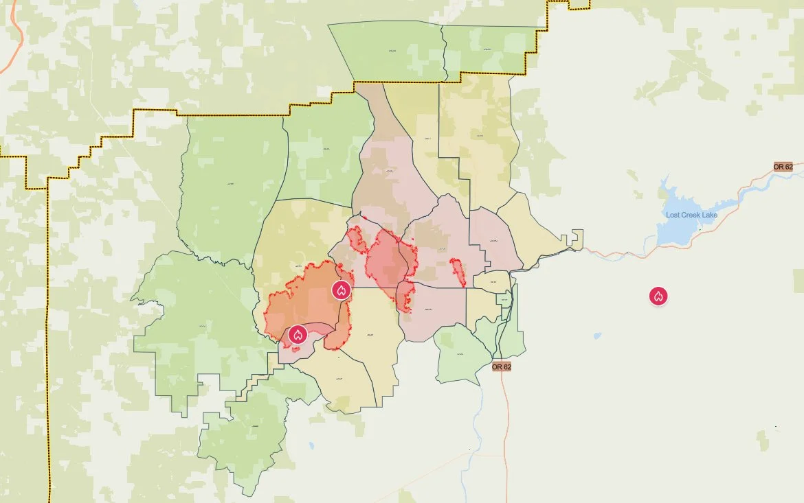
The latest evacuation map showing level 1, 2, and 3 evacuations due to the East Evans Creek Fire. Residents should use the interactive Genasys map to check current conditions for a specific address. (Project Genasys)
EVACUATION LEVELS
Jackson County Sheriff’s Office and Jackson County Emergency Management continue maintaining Level 1, Level 2 and Level 3 notices around the fire. Zones now stretch into Douglas County. Residents in Level 3 zones should leave immediately.
Level 3: Go Now
JAC-017
JAC-109
JAC-124
JAC-126
JAC-127A
JAC-149B
JAC-127A was created by splitting JAC-127 along Highway 227. The Level 3 area follows Highway 227 from its intersection with Highway 62 to Taylor Road and extends north along Highway 62 to River Heights Road.
Level 2: Be Set
JAC-016
JAC-026
JAC-111
JAC-112
JAC-127B
JAC-131
JAC-132
JAC-133
JAC-134
JAC-147
JAC-148
JAC-149A
JAC-026 includes the 15500 through 18000 blocks of East Evans Creek Road.
Level 1: Be Ready
JAC-003
JAC-004
JAC-014
JAC-036
JAC-158
SHC-151
SHC-152
SHC-153
SHC-154
SHC-156
SHC-157
DOU-1012
DOU-1015

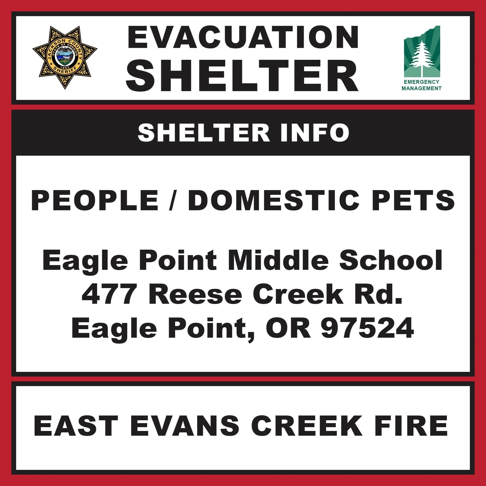
EVACUATION SHELTER IN EAGLE POINT
The evacuation shelter for residents and domestic pets is located at:
Eagle Point Middle School
477 Reese Creek Road, Eagle Point, OR 97524
The previous shelter at Hanby Middle School in Gold Hill is closed.
Pets are welcome at the Eagle Point shelter but are not permitted inside the school building. The American Red Cross is providing an area on the property for domestic pets.
People needing additional medical assistance or livestock sheltering help should call 541-776-7206.
Horses may be taken to:
Jackson County Expo
21 Peninger Road, Central Point
Owners should call before arriving to confirm space is available.

ROAD AND PUBLIC LAND CLOSURES
East Evans Creek Road remains closed to public traffic at Meadows Road.
The Bureau of Land Management has also closed:
West Fork Evans Creek Road
Rock Creek Road
BLM-administered lands surrounding the fire
Public entry into the BLM closure area is prohibited, including hunting, hiking and camping.
Officials are asking people to avoid the incident area so firefighters, engines and heavy equipment can operate safely.
SMOKE AND AIRSPACE RESTRICTIONS
Smoke may settle into valleys and other low-lying areas, reducing visibility and affecting air quality across nearby communities.
A 24-hour temporary flight restriction remains in effect over the incident. Flying a drone near the fire is illegal and may force firefighting aircraft to suspend operations.
CAUSE
The East Evans Creek Fire began at approximately 2:41 p.m. Friday, July 10, after a vehicle crashed into a power pole and ignited dry vegetation. The Jackson County Sheriff’s Office continues investigating the cause of the crash.


More Firewatch




ODF Southwest Oregon’s 4 Alpha Fox helicopter has completed its 75-day seasonal contract after introducing approved night-vision wildfire flights this year. One recent after-dark mission located three lightning-caused fires.