
Weekend Forecast: Red Flag Warning, Gusty Winds Raise Fire Danger East of Cascades
Fire weather concerns continue through Sunday as hot, dry and windy conditions grip areas east of the Cascades.
WEEKEND WEATHER FAST FACTS
Fire Weather: Red Flag Warning through 9 p.m. Sunday.
East of the Cascades: Hot, dry and windy, with highs mainly in the 80s and 90s.
Western Valleys: Hot and mostly sunny, with highs from the upper 80s to mid-90s.
Mountains: Cooler, but breezy across exposed ridges and passes.
Coast: Marine clouds and highs mostly in the 60s.
KLAMATH FALLS, Ore. — A Red Flag Warning is in effect from 11 a.m. Friday through 9 p.m. Sunday for portions of Southern Oregon and Northern California as strong southwest winds, very low humidity and critically dry fuels create conditions that could allow wildfires to spread rapidly.
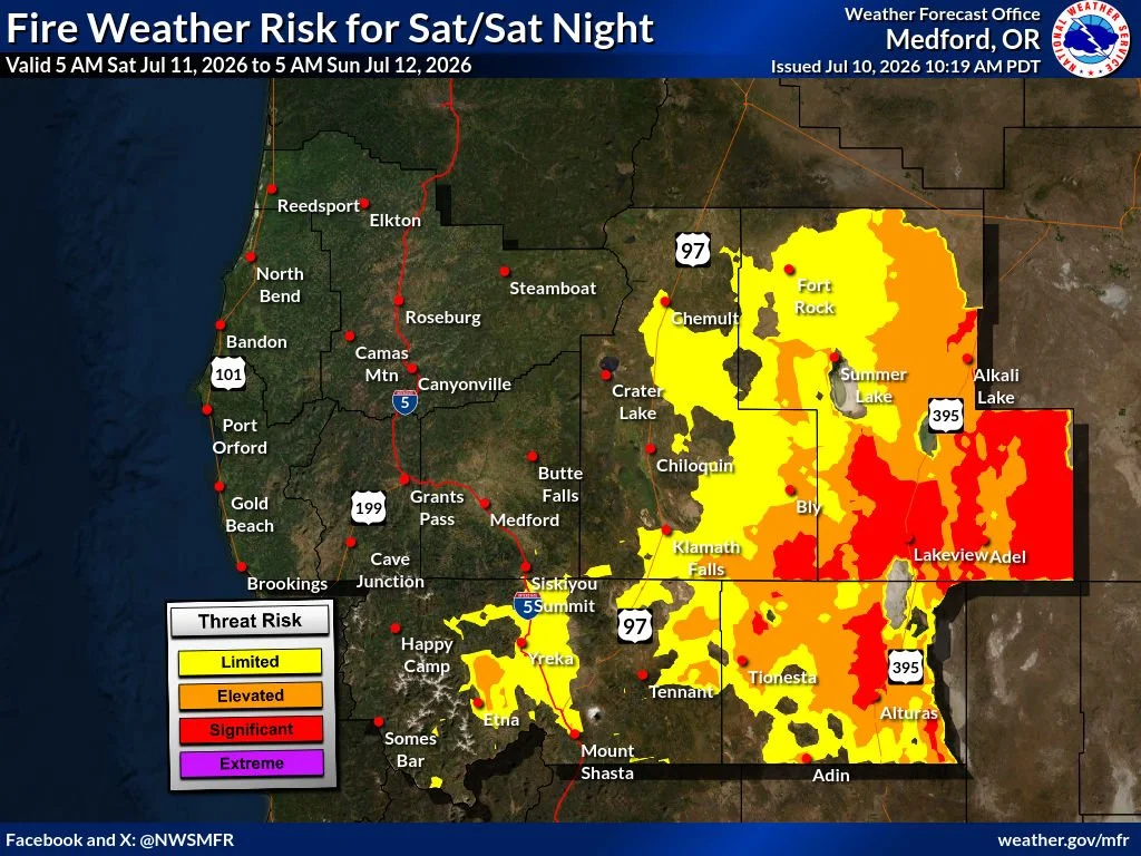
The warning covers the Klamath Basin and portions of the Fremont-Winema National Forest in Oregon, along with most of Modoc County and the Modoc National Forest in California.
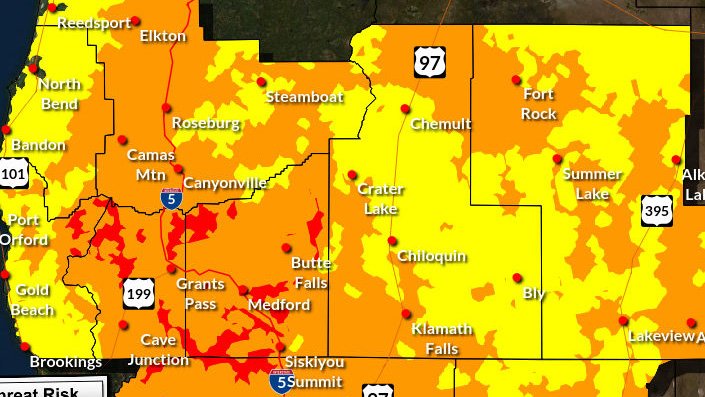
A Red Flag Warning is in effect through 9 p.m. Sunday for much of Modoc County and portions of the Klamath Basin and Fremont-Winema National Forest. The shaded area shows where gusty winds, low humidity and critically dry fuels could allow new fires to spread rapidly. Map: National Weather Service
Southwest winds of 15 to 25 mph are expected, with peak gusts reaching 30 to 40 mph. Minimum relative humidity could fall to between 10% and 15%, with the most critical conditions developing during the afternoon and evening hours Friday, Saturday and Sunday.
“The combination of gusty winds, low humidity and critically dry fuels will allow any fires that develop to spread rapidly,” the National Weather Service said.


Winds are expected to ease overnight. Humidity recovery should be good Saturday morning before falling into the moderate range Sunday and Monday mornings.
A Red Flag Warning does not mean a wildfire is currently burning. It means weather and fuel conditions could allow fires to start more easily, grow quickly and become difficult to control.
Residents and visitors should follow all current fire restrictions, avoid parking vehicles on dry grass, properly dispose of smoking materials and refrain from using outdoor equipment that could produce sparks.
Beyond the warning area, the weekend forecast calls for hot conditions across inland valleys, cooler temperatures in the mountains and persistent marine influence along the coast. Some inland areas east of the Cascades should begin cooling Monday as cloud cover increases.
Strong, gusty winds coupled with low humidity over portions of northern California and areas east of the Cascades will bring critical fire weather conditions in those areas each afternoon and evening Friday through Sunday. Fires that develop could spread rapidly. Keep vehicles off dry grass. Avoid using outdoor equipment that could cause sparks and properly dispose of cigarettes. (NWS Medford)
Regional forecast through Monday
Klamath Basin
Klamath Falls, Chiloquin, Merrill, Malin and Tulelake will remain warm, dry and breezy through the weekend.
Klamath Falls is forecast to reach the upper 80s Friday through Sunday before cooling slightly into the mid-to-upper 80s Monday. Afternoon west and southwest winds could gust into the mid-to-upper 20s.
Chiloquin should remain in the mid-80s through Monday. Merrill, Malin and Tulelake will be warmer, with highs near or just above 90 Friday and Saturday, followed by the upper 80s Sunday and mid-80s Monday. Overnight lows will generally range from the upper 40s to upper 50s.
Rogue Valley
Medford, Ashland, Central Point, Eagle Point and Grants Pass will remain hot through Monday, although the Rogue Valley is outside the current Red Flag Warning.
Most communities will reach the upper 80s to mid-90s Friday and Saturday. Temperatures are expected to climb again Sunday, with parts of the valley reaching the mid-to-upper 90s. Monday should remain hot, with highs generally in the lower-to-mid 90s.
Overnight lows will gradually rise through the weekend, reaching the upper 50s and lower 60s in many locations by Sunday night.
Mountains
The Cascades, Siskiyou Mountains, Crater Lake, Lake of the Woods and Mount Ashland will be cooler than the surrounding valleys, but breezy afternoon conditions will continue through much of the weekend.
Higher elevations should generally see highs in the upper 60s and 70s, with warmer readings possible around lower-elevation lakes and recreation areas. Overnight temperatures will commonly fall into the 40s and lower 50s.
West and southwest winds could gust between 25 and 30 mph in exposed areas Friday and Saturday. Skies should remain mostly sunny Friday, with increasing clouds at times Saturday and Sunday. Monday should be mostly sunny to partly cloudy.
Oregon Outback
Lakeview, southern Lake County and the Warner Mountains will experience some of the strongest winds in the region through Sunday.
Lakeview-area highs should remain in the lower-to-mid 80s, with southwest wind gusts reaching approximately 30 to 38 mph during the afternoon and evening hours. Mountain locations will be cooler but could experience stronger winds along exposed ridges.
Sunday will become partly sunny before temperatures fall into the lower 80s Monday. Increasing clouds and a slight chance of showers may develop Monday night.
Modoc County
Alturas and the Modoc National Forest are included in the Red Flag Warning through Sunday evening.
Alturas is forecast to reach the lower 90s Friday, the mid-90s Saturday and around 90 Sunday. Southwest winds will become gusty each afternoon, with the strongest gusts potentially reaching 30 to 40 mph across the warning area.
Temperatures should fall into the mid-80s Monday as cloud cover increases. A few showers or thunderstorms could develop later Monday, although the timing and coverage remain uncertain.
Eastern Klamath County
Bly and portions of the Fremont-Winema National Forest will remain under critical fire-weather conditions through Sunday evening.
Bly is forecast to reach around 90 degrees Friday and Saturday, followed by the upper 80s Sunday. Monday should be cooler and cloudier, with a high in the lower 80s.
Southwest winds of 15 to 25 mph, with gusts as high as 30 to 40 mph, will combine with humidity near 10% to 15% across the broader warning area.
Siskiyou County
Yreka and the Shasta Valley will remain hot and dry through Monday but are outside the current Red Flag Warning.
Yreka is forecast to reach the lower-to-mid 90s each afternoon, with mostly sunny skies Friday and a mixture of sunshine and clouds through the weekend. Montague and other parts of the Shasta Valley should experience similar temperatures.
Afternoon and evening winds will become locally breezy, particularly through the Shasta Valley and near exposed terrain. Overnight lows should remain in the upper 50s to lower 60s.
Coast
Brookings-Harbor, Gold Beach and Crescent City will remain significantly cooler than inland communities.
Highs will generally range from around 60 to the upper 60s through Monday. Brookings may warm into the upper 60s Sunday, while Gold Beach should reach the mid-60s. Crescent City will remain near the lower 60s.
Clouds, marine air and occasional periods of sunshine will continue throughout the weekend. Overnight lows will remain in the lower-to-mid 50s.
Forecast temperatures, winds and warning boundaries may change as the weekend progresses. Residents should continue monitoring National Weather Service forecasts and information from local emergency officials.

RED FLAG WARNING
URGENT - FIRE WEATHER MESSAGE
National Weather Service Medford OR
329 AM PDT Fri Jul 10 2026

CAZ285-ORZ624-102230-
/O.CON.KMFR.FW.W.0007.260710T1800Z-260713T0400Z/
Modoc County Except for the Surprise Valley-
Klamath Basin and the Fremont-Winema National Forest-
329 AM PDT Fri Jul 10 2026

...RED FLAG WARNING REMAINS IN EFFECT FROM 11 AM THIS MORNING TO
9 PM PDT SUNDAY FOR STRONG GUSTY WIND AND LOW RH FOR FIRE WEATHER
ZONES 285 AND 624...

* IMPACTS...The combination of gusty winds, low humidity and
  critically dry fuels will allow any fires that develop to
  spread rapidly.

* AFFECTED AREA...In California, Fire Weather Zone 285,
  including Modoc National Forest. In Oregon, Fire Weather Zone
  624, including the Fremont National Forest in the southeast
  portion of the zone.

* WIND...Southwest 15 to 25 mph with peak gusts of 30 to 40 mph.

* MINIMUM RELATIVE HUMIDITY...10 to 15 percent.

* DETAILED URL...View the hazard area in detail at
  https://weather.gov/wrh/hazards?wfo=mfr

* ADDITIONAL DETAILS...Winds are expected to ease overnight and
  recoveries will be in the good (Saturday morning) to moderate
  range (Sunday/Monday mornings).

PRECAUTIONARY/PREPAREDNESS ACTIONS...

Follow all fire restrictions. You can find your county`s
emergency sign up form as well as links to fire restrictions at
weather.gov/medford/wildfire. One less spark, one less wildfire.

Be sure you`re signed up for your county`s emergency alert
system. Familiarize yourself with your emergency plan and make
sure you listen to emergency services. Visit ready.gov/plan for
more information.

A Red Flag Warning is issued when we identify weather conditions
that promote rapid spread of fire which may become life-
threatening. This does not mean there is a fire. These conditions
are either occurring now or will begin soon. It is important to
have multiple ways to receive information from authorities.
Cover image: The historic Harris Schoolhouse sits below Winter Ridge along Oregon Route 31 between Summer Lake and Paisley. The surrounding high-desert landscape reflects the hot, dry and windy conditions raising fire-weather concerns east of the Cascades this weekend. Photo by Sally/Flickr.


Recent Weather News

A Frost Advisory is in effect early Wednesday for parts of Klamath, Lake, and Modoc counties as a cooler air mass and clearing skies could push temperatures into the low to mid 30s. Sensitive plants, pets, livestock, and agriculture may be affected.