
Lightning Threat Prompts Red Flag Warning East of Cascades
Thunderstorms are expected around Klamath and Lake counties Monday afternoon, bringing the risk of new fire starts on dry fuels.
MEDFORD, Ore. — A Red Flag Warning remains in effect Monday afternoon and evening for portions of south-central Oregon, where thunderstorms could bring abundant lightning over dry fuels one night after hundreds of lightning strikes were recorded across the same general region.
The National Weather Service in Medford said thunderstorm activity is expected east of the Cascades around Klamath and Lake counties this afternoon. Lightning is the main fire-weather concern, though storms may also bring hail up to three-quarters of an inch and wind gusts around 40 to 45 mph.
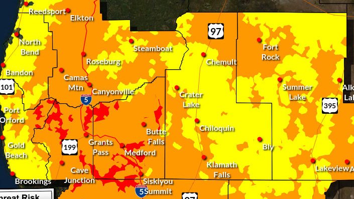
The warning is in effect from 2 to 8 p.m. Monday for northern sections of Fire Weather Zones 624 and 625, including parts of the Klamath Basin, the Fremont-Winema National Forest and the south-central Oregon desert, including BLM land in eastern Lake and western Harney counties.


Forecasters said storms are expected to move north and northeast around 20 to 25 mph. Storms may be a mix of dry and wet thunderstorms, with isolated outflow gusts up to 45 mph.
The concern is not just lightning, but lightning over a landscape already primed for fire.
Thunderstorms are expected east of the Cascades around Klamath and Lake counties Monday afternoon, with lightning, hail up to three-quarters of an inch and gusty winds all possible. Graphic courtesy of the National Weather Service Medford.
“Abundant lightning on dry fuels will likely create new ignitions across the region,” the warning said. “Any fires that develop could spread rapidly. Numerous new fire starts could overwhelm initial attack.”
A separate Red Flag Warning from the National Weather Service in Boise also covers portions of eastern Oregon and southern Idaho Monday, including the Burns BLM, Steens Mountain, Southern Grasslands, Central Canyonlands and Northwestern Vale BLM fire weather zones. That warning calls for scattered thunderstorms with abundant lightning and gusty, erratic winds up to 50 mph.
A Red Flag Warning does not mean there is a fire. It means weather conditions are expected to support rapid fire spread if a fire starts.
A Red Flag Warning remains in effect Monday afternoon and evening for parts of the Klamath Basin, Fremont-Winema National Forest and south-central Oregon desert, where abundant lightning on dry fuels could create new fire starts. Map courtesy of the National Weather Service.
Residents and visitors are urged to follow all fire restrictions, avoid activities that could create sparks and make sure they have more than one way to receive emergency information. Outdoor plans should include a place to go if thunderstorms develop nearby.
The National Weather Service also reminds people to go indoors when thunder is heard. Avoid exposed areas such as mountain summits, lakes and large fields during storms.

Full warning from the National Weather Service in Medford
Red Flag Warning
URGENT - FIRE WEATHER MESSAGE
National Weather Service Medford OR
1212 AM PDT Mon Jul 6 2026


ORZ624-625-070300-
/O.CON.KMFR.FW.W.0005.260706T2100Z-260707T0300Z/
Klamath Basin and the Fremont-Winema National Forest-
South Central Oregon Desert including the BLM Land in Eastern
Lake and Western Harney Counties-
1212 AM PDT Mon Jul 6 2026

...RED FLAG WARNING REMAINS IN EFFECT FROM 2 PM THIS AFTERNOON TO
8 PM PDT THIS EVENING FOR ABUNDANT LIGHTNING ON DRY FUELS FOR
FIRE WEATHER ZONES 624 AND 625...

* IMPACTS...Abundant lightning on dry fuels will likely create
  new ignitions across the region. Any fires that develop could
  spread rapidly. Numerous new fire starts could overwhelm
  initial attack.

* AFFECTED AREA...Northern sections of Fire Weather Zones 624 and
  625.

* THUNDERSTORMS...Moving north and northeast around 20 to 25
  mph. Storm mode will be a mix of dry and wet thunderstorms.

* OUTFLOW WINDS...Isolated gusts up to 45 mph.

* DETAILED URL...View the hazard area in detail at
  https://weather.gov/wrh/hazards?wfo=mfr

PRECAUTIONARY/PREPAREDNESS ACTIONS...

Follow all fire restrictions. You can find your county`s
emergency sign up form as well as links to fire restrictions at
weather.gov/medford/wildfire. One less spark, one less wildfire.

Be sure you`re signed up for your county`s emergency alert
system. Familiarize yourself with your emergency plan and make
sure you listen to emergency services. Visit ready.gov/plan for
more information.

A Red Flag Warning is issued when we identify weather conditions
that promote rapid spread of fire which may become life-
threatening. This does not mean there is a fire. These conditions
are either occurring now or will begin soon. It is important to
have multiple ways to receive information from authorities.

+++
URGENT - FIRE WEATHER MESSAGE
National Weather Service Boise ID
801 AM MDT Mon Jul 6 2026
...SCATTERED THUNDERSTORMS THIS AFTERNOON AND EVENING...
.Mid level moisture and an upper level shortwave will trigger
scattered thunderstorms as the atmosphere becomes unstable this
afternoon. The thunderstorms are expected to develop near the
southern Oregon and southern Idaho boarder this afternoon and move
toward the northeast into the early evening hours. Rainfall
amounts with these storms are expected to be less than one tenth
of an inch in most areas. Expect gusty and erratic winds up to 50
mph in the vicinity of these thunderstorms.
IDZ423-ORZ670>674-062215-
/O.NEW.KBOI.FW.W.0009.260706T1800Z-260707T0300Z/
Owyhee Mountains-Burns BLM-Steens Mountain-Southern Grasslands-
Central Canyonlands-Northwestern Vale BLM-
801 AM MDT Mon Jul 6 2026 /701 AM PDT Mon Jul 6 2026/
...RED FLAG WARNING IN EFFECT FROM NOON MDT /11 AM PDT/ TODAY TO
9 PM MDT /8 PM PDT/ THIS EVENING FOR LIGHTNING FOR OWYHEE
MOUNTAINS...BURNS BLM...STEENS MOUNTAIN...SOUTHERN GRASSLANDS...
CENTRAL CANYONLANDS AND NORTHWESTERN VALE BLM...WHICH ARE FIRE
WEATHER ZONES 423...670...671...672...673 AND 674...
The National Weather Service in Boise has issued a Red Flag
Warning for lightning, which is in effect from noon MDT /11 AM
PDT/ today to 9 PM MDT /8 PM PDT/ this evening.
* AFFECTED AREA...In Idaho, Fire Weather Zone 423 Owyhee
Mountains. In Oregon, Fire Weather Zones 670 Burns BLM, 671
Steens Mountain, 672 Southern Grasslands, 673 Central
Canyonlands and 674 Northwestern Vale BLM.
* TIMING...From noon MDT /11 AM PDT/ today to 9 PM MDT /8 PM
PDT/ this evening.
* THUNDERSTORMS...Scattered coverage with abundant lightning.
* OUTFLOW WINDS...Gusty erratic winds up to 50 mph.
* IMPACTS...Any fire that develops will catch and spread
quickly. Outdoor burning is not recommended.
PRECAUTIONARY/PREPAREDNESS ACTIONS...
A Red Flag Warning means that critical fire weather conditions
are either occurring now, or will occur shortly.Cover image: Lightning flashes over forested mountains in Eastern Oregon. A Red Flag Warning is in effect Monday for parts of south-central and eastern Oregon, where thunderstorms could bring abundant lightning on dry fuels and spark new fires. Photo by Andrew Kearns via Flickr.


Recent Weather News

A Frost Advisory is in effect early Wednesday for parts of Klamath, Lake, and Modoc counties as a cooler air mass and clearing skies could push temperatures into the low to mid 30s. Sensitive plants, pets, livestock, and agriculture may be affected.