
Fire Weather Watch upgraded as abundant lightning and gusty outflow winds raise fire danger Wednesday
FAST FACTS
Alert: Red Flag Warning
When: Wednesday, July 22, from 11 a.m. to 11 p.m.
Where: Portions of Jackson, Klamath and Lake counties, along with areas near and east of the Cascades
Main Threat: Abundant lightning over critically dry fuels
Storm Chances: 25% to 45% in the Red Flag Warning area
Winds: Thunderstorm outflow gusts could reach 45 mph
Fire Concern: New lightning-caused starts and rapid fire spread
Smoke: Periods of wildfire smoke expected across parts of Southern Oregon and Northern California through at least Wednesday
Air Quality: Air Quality Alert remains in effect for northern Jackson County
Wednesday Highs: Around 104° in Medford and 92° in Klamath Falls
MEDFORD, Ore. — A Fire Weather Watch issued Monday for portions of Southern Oregon has been upgraded to a Red Flag Warning as forecasters grow more confident that thunderstorms could bring abundant lightning over critically dry fuels Wednesday.
The National Weather Service in Medford issued the Red Flag Warning for Wednesday from 11 a.m. to 11 p.m., covering a broad area that includes portions of Jackson, Klamath and Lake counties, along with areas near and east of the Cascades.
The warning replaces the Fire Weather Watch previously in effect.


Forecasters say monsoonal moisture moving into the region will combine with atmospheric instability to increase thunderstorm activity Wednesday afternoon and evening. While many of the storms are expected to produce rain, lightning could extend well outside the wetter portions of the storms and ignite new fires in dry vegetation.
Any new starts could be complicated by gusty and erratic winds generated by nearby thunderstorms.
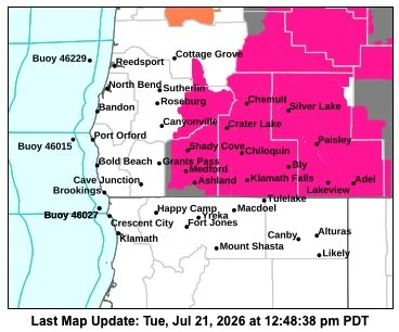
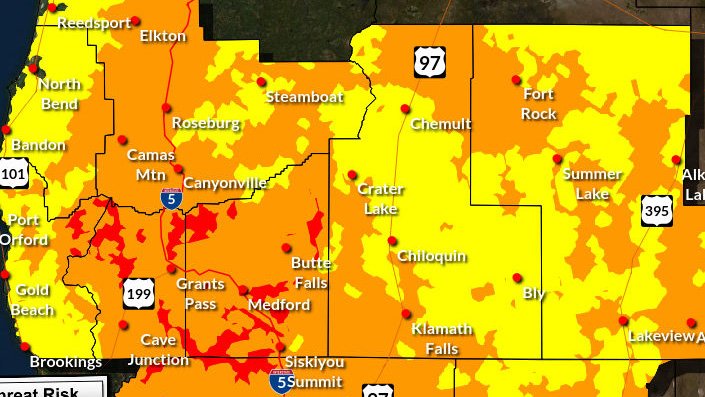
The National Weather Service detailed hazards map shows a broad Red Flag Warning covering much of Southern Oregon east of the Cascades, including Klamath and Lake counties and portions of Jackson and Douglas counties. Additional hazards, including air quality alerts, remain in effect elsewhere across the region. National Weather Service
LIGHTNING THREAT INCREASES WEDNESDAY
Thunderstorms are expected to generally move from south to north or northeast at around 20 mph Wednesday.
The National Weather Service said storms will be mostly wet, but dry lightning strikes remain possible outside the main rain cores.
Outflow winds could also become a concern, with isolated gusts reaching as high as 45 mph.
Those winds can cause sudden shifts in fire behavior, particularly if lightning ignites new fires or if storms pass near existing incidents.
The strongest thunderstorm activity may develop across portions of the Cascades and east side, including areas near and north of Diamond Lake and across northern Klamath County.
Thunderstorm chances Wednesday are generally between 25% and 45% within the Red Flag Warning area. Lower chances extend into western Douglas County, western Siskiyou County and portions of Modoc County.
DRY FUELS RAISE RISK OF NEW FIRE STARTS
The warning comes during a period of extremely dry summer conditions across much of Southern Oregon and Northern California.
A Red Flag Warning does not mean a wildfire is occurring. It means weather conditions are expected that could allow fires to start more easily and spread rapidly.
Lightning is a particular concern because a single thunderstorm can produce numerous fire starts across a wide area, sometimes in remote terrain where fires may not be detected immediately.
Even storms that bring rain can ignite fires when lightning strikes dry vegetation outside the heaviest precipitation.
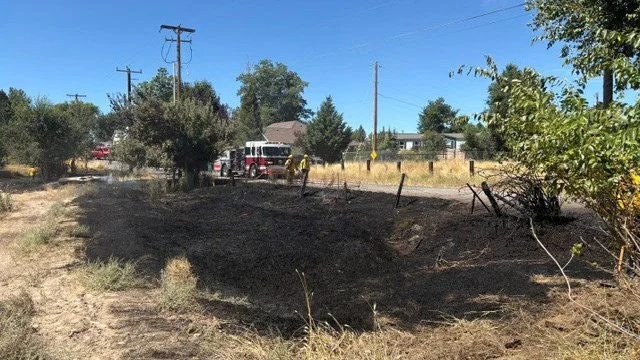
Fire crews across the region are already responding to active wildfires, including the East Evans Creek Fire in Jackson County and several smaller incidents that have tested local and regional resources during the past week.
SMOKE CONTINUES ACROSS PARTS OF THE REGION
Wildfire smoke will remain another concern through at least Wednesday.
According to the National Weather Service, fires in northwest Jackson County and central Oregon are continuing to send smoke across portions of Southern Oregon and Northern California.
The greatest smoke impacts are expected in northern Jackson County, while periods of smoke are also possible elsewhere in Jackson County and across eastern Douglas, Klamath and Lake counties.
Smoke may also periodically reach Josephine, Siskiyou and Modoc counties depending on winds.
An Air Quality Alert remains in effect for northern Jackson County through Wednesday afternoon, with air quality potentially fluctuating rapidly as smoke moves through valleys and basins.
People sensitive to wildfire smoke should limit strenuous outdoor activity when air quality deteriorates and monitor current conditions before spending extended periods outside.

HOT WEATHER ADDS TO FIRE CONCERNS
Temperatures will remain hot across much of the region as thunderstorms arrive.
The National Weather Service forecast for Medford calls for a high near 104 degrees Wednesday, with a slight chance of afternoon thunderstorms.
Klamath Falls is forecast to reach around 92 degrees, also with a chance of showers and thunderstorms developing later in the day.
The combination of heat, dry fuels, lightning and potentially strong thunderstorm outflow winds will make Wednesday a particularly important day for fire weather across the region.
Residents should avoid activities that could create sparks, remain alert for new smoke columns and be prepared for rapidly changing weather if thunderstorms develop nearby.
Weather Messages & Alerts


Recent Weather News

The National Weather Service has issued frost advisories and freeze warnings across parts of Southern Oregon and Northern California as the coldest temperatures of the season arrive. Frost and freezing conditions are expected Sunday and Monday mornings, with possible slick roads in Lake and Modoc counties and sneaker wave danger along the coast.