
Red Flag Warning Covers Klamath Basin, Siskiyou County
Gusty winds and humidity as low as 9 percent could allow fires to spread rapidly through Monday evening.
Fire Weather Risk: The National Weather Service shows significant fire weather risk across portions of the Klamath Basin, eastern Southern Oregon, and northern California Monday as gusty winds combine with very low humidity. National Weather Service Medford.
KLAMATH FALLS, Ore. — A broad Red Flag Warning is in effect Monday across much of the Klamath Basin and northern California as gusty winds combine with extremely dry air to create conditions favorable for rapid fire growth.
The National Weather Service in Medford has the warning in effect from noon until 8 p.m. Aug. 31 for portions of southern Oregon and northern California, including the Klamath Basin, Fremont-Winema National Forest, western Klamath National Forest, Scott Valley, Shasta Valley, and portions of Siskiyou and Modoc counties.
In Oregon, the warning includes much of Fire Weather Zone 624, although the Highway 97 corridor from Modoc Point north toward Chemult is excluded.
The concern Monday is not simply hot weather. It is the combination of wind, very low humidity, and vegetation that remains dry late in the fire season.
Humidity is expected to fall to between 9 and 15 percent across the warning area. Southwest winds of 10 to 20 mph are expected across much of the region, with gusts reaching around 30 mph. Winds in the Shasta Valley could reach 15 to 25 mph with gusts as high as 35 mph.


Those conditions can allow a new fire to grow quickly and can make existing fires more difficult to control.
The National Weather Service said critical combinations of wind and dry air are expected Monday afternoon in the Scott and Shasta valleys and east of the Cascades.
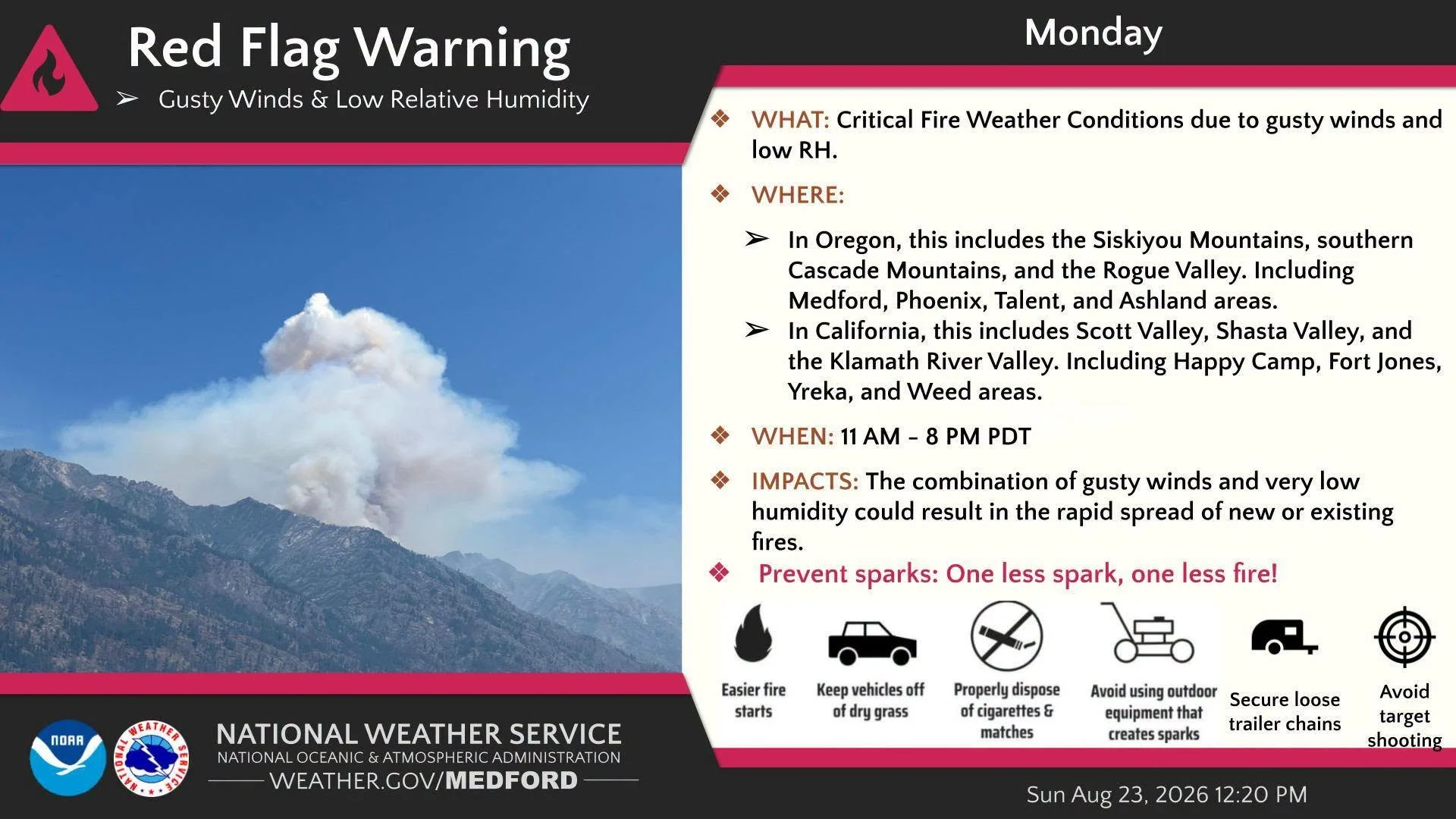
Critical Fire Weather: The National Weather Service warns that gusty winds and very low humidity can allow new or existing fires to spread rapidly during Red Flag conditions. National Weather Service Medford.
What a Red Flag Warning means
A Red Flag Warning does not mean a wildfire is occurring.
Instead, it means weather conditions are developing that could allow a fire that starts to spread quickly and potentially become dangerous.
Fire officials and forecasters are urging residents to avoid activities capable of producing sparks or flames, follow current fire restrictions, keep vehicles out of dry vegetation, secure trailer chains, and use extra caution with outdoor equipment.
The warning comes as fire danger remains elevated across large portions of eastern Southern Oregon and northern California.
A change arrives later this week
Monday appears to be the most critical day in the immediate forecast.
Gusty winds are expected to continue Tuesday, but humidity should begin increasing. A front is then expected to move inland Wednesday, bringing significantly cooler temperatures and higher humidity. The National Weather Service says wetting rain is likely west of the Cascades Wednesday, with lighter precipitation possible farther east.
Until then, officials are asking residents across the warning area to remain especially careful with anything that could provide an ignition source.
Even a small spark can become difficult to control quickly when strong winds, single-digit or near-single-digit humidity, and dry vegetation come together.

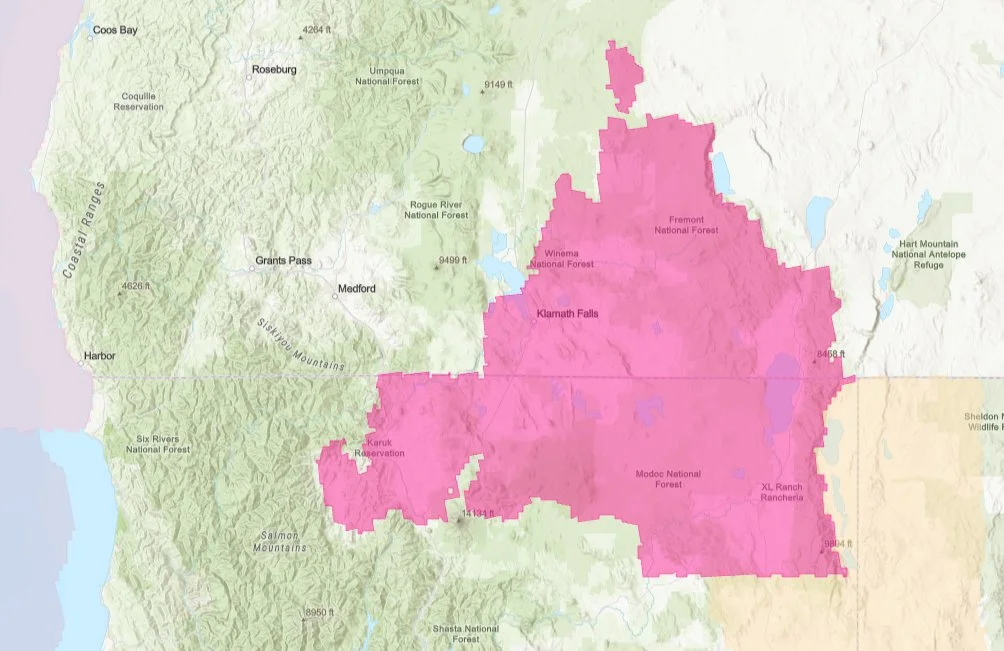
Red Flag Warning Area: A Red Flag Warning covers a broad area of eastern Southern Oregon and northern California Monday, including portions of the Klamath Basin, Siskiyou County, and Modoc County. National Weather Service.
Weather Messages & Alerts
Red Flag Warning
URGENT - FIRE WEATHER MESSAGE
National Weather Service Medford OR
439 AM PDT Mon Aug 31 2026

CAZ280-281-284-285-ORZ624-312345-
/O.CON.KMFR.FW.W.0022.260831T1900Z-260901T0300Z/
Western Klamath National Forest-Central Siskiyou County Including Shasta Valley-Siskiyou County from the Cascade Mountains East and South to Mt Shasta-Modoc County Except for the Surprise Valley-Klamath Basin and the Fremont-Winema National Forest-439 AM PDT Mon Aug 31 2026

...RED FLAG WARNING REMAINS IN EFFECT FROM NOON TODAY TO 8 PM PDT THIS EVENING FOR STRONG GUSTY WIND AND LOW RH FOR FIRE WEATHER  ZONES 280, 281, 284, 285, AND 624...

* AFFECTED AREA...In California...The Scott Valley in Fire  weather zone 280, Fire weather zone 281, Fire weather zone 284
  excepting the southeast portion of the zone, and Fire weather  zone 285. In Oregon...Fire weather zone 624, excepting the
  Highway 97 corridor from Modoc Point to Chemult.

* WIND...South winds 10 to 20 mph with gusts to 30 mph in the Scott Valley, and 15 to 25 mph with gusts to 35 mph in the
  Shasta Valley. Elsewhere, southwest winds 10 to 20 mph with gusts to 30 mph.

* HUMIDITY...Minimum humidity 9 to 15 percent.

* DETAILED URL...View the hazard area in detail at https://weather.gov/wrh/hazards?wfo=mfr

PRECAUTIONARY/PREPAREDNESS ACTIONS...

Follow all fire restrictions. You can find your county`s emergency sign up form as well as links to fire restrictions at
weather.gov/medford/wildfire. One less spark, one less wildfire.

Be sure you`re signed up for your county`s emergency alert system. Familiarize yourself with your emergency plan and make sure you listen to emergency services. Visit ready.gov/plan for more information.

A Red Flag Warning is issued when we identify weather conditions that promote rapid spread of fire which may become life-threatening. This does not mean there is a fire. These conditions are either occurring now or will begin soon. It is important to have multiple ways to receive information from authorities.

Keep Reading


The National Weather Service has issued frost advisories and freeze warnings across parts of Southern Oregon and Northern California as the coldest temperatures of the season arrive. Frost and freezing conditions are expected Sunday and Monday mornings, with possible slick roads in Lake and Modoc counties and sneaker wave danger along the coast.