
East Evans Creek Fire Grows to 5,370 Acres as Crews Battle Spot Fires
Additional Resources Arrive After Fire Threatens Homes Along East Evans Creek and Morrison Creek Roads

Name: East Evans Creek Fire
Location: Approximately seven miles west of Shady Cove
Acres: 5,370
Containment: 5%, latest reported
Current activity: Extreme fire behavior and spotting across the north, northwest and northeast
Spot fires: Multiple spots identified outside the northeastern perimeter
Structure protection: Homes defended along East Evans Creek Road and Morrison Creek
Evacuations: JAC-124 and JAC-148A remain at Level 3: Go Now
Current concerns: High temperatures, poor humidity recovery, dry thunderstorms and erratic outflow winds
Cause: Vehicle crashed into a power pole; the cause of the crash remains under investigation
Updated: Tuesday morning, July 14, 2026
Active fire burns through forested terrain on the East Evans Creek Fire overnight as crews worked to contain spot fires, cool hot areas and strengthen control lines. (Oregon Department of Forestry)
East Evans Creek Fire AM update for 7/14/26.
Updated to add ODF’s Morning Briefing video.
SAMS VALLEY, Ore. — The East Evans Creek Fire grew by 1,742 acres overnight, reaching an estimated 5,370 acres after extreme fire behavior and spotting challenged firefighters across the northern portions of the incident.
An overnight infrared flight showed significant growth on the north, northwest and northeast sides of the fire. Multiple spot fires were identified outside the northeastern perimeter, and crews are working to reach and contain those areas.
Fire advanced to the edge of several properties along East Evans Creek Road and Morrison Creek on Monday evening. Oregon State Fire Marshal crews worked alongside wildland firefighters to protect homes, extinguish ember-caused ignitions and quickly suppress spot fires before they could spread.
ODF said those structures were successfully defended. The Tuesday morning update did not report any structures lost.
Additional crews, engines, heavy equipment, overhead personnel and aircraft arrived overnight, with more resources expected throughout Tuesday. Firefighters are preparing for another difficult operational period as high temperatures, poor humidity recovery, isolated dry thunderstorms and gusty outflow winds threaten renewed fire activity.
The latest reported containment remains 5%. ODF did not release a revised containment estimate Tuesday morning.
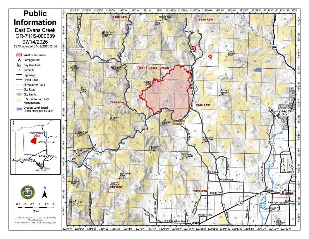
The July 14 public information map shows the latest mapped perimeter of the East Evans Creek Fire, nearby communities, major roads and evacuation areas. View this map and the latest infrared, operations and briefing maps on our dedicated Firewatch maps page. (Oregon Department of Forestry/Oregon State Fire Marshal)
View the latest maps: https://jeffersondailynews.com/firewatch/evans-creek-fire-maps
OVERNIGHT GROWTH PUSHES FIRE TO 5,370 ACRES
The overnight infrared flight mapped the fire at 5,370 acres, an increase of 1,742 acres from Monday morning’s 3,628-acre estimate.
ODF said the fire remained active through Monday evening, with extreme fire behavior and spotting creating difficult conditions across the northern portions of the incident.
Spot fires are ignitions outside the main fire perimeter, often caused when wind carries burning embers into unburned vegetation. Multiple spots were detected beyond the northeastern edge of the fire, and crews are actively working to gain access and contain them.
CREWS DEFEND HOMES AS FIRE REACHES PROPERTIES
Fire activity advanced to the edge of several properties along East Evans Creek Road and Morrison Creek.
OSFM structural crews provided point protection where homes faced the greatest threat. Firefighters extinguished ember-caused ignitions and suppressed spot fires near structures before they could grow.
As conditions moderated overnight, crews cooled active areas, slowed fire growth and reinforced suppression work completed during Monday’s most active burning period.
Structural firefighters will remain paired with wildland crews Tuesday to assess homes, watch for falling embers and respond quickly to new ignitions.
Two helicopters work above the East Evans Creek Fire as heavy smoke fills the surrounding terrain. Aviation resources continued supporting ground crews into Monday evening by cooling active areas and slowing fire spread. (Oregon Department of Forestry)
HELICOPTERS AND HEAVY EQUIPMENT SUPPORT CREWS
Aviation resources continued supporting firefighters well into Monday evening.
Helicopters cooled active fire with water drops, while air tankers used retardant to slow movement and reinforce firelines where conditions allowed.
Heavy equipment operators improved access through steep terrain and constructed fireline to help ground crews reach active areas. Firefighters also aggressively engaged multiple spot fires overnight.
Aircraft will continue cooling hotspots, slowing fire spread and supporting containment efforts Tuesday as visibility and weather conditions allow.
ADDITIONAL RESOURCES ARRIVE
Additional hand crews, engines, heavy equipment, aviation resources and overhead personnel ordered by ODF and OSFM arrived overnight. More resources are expected throughout the day.
Incident managers said the increased staffing reflects the growing complexity of the fire and the need to position resources where they can have the greatest effect.
Community members should expect increased emergency vehicle and heavy-equipment traffic around the incident. Officials are asking people to avoid closed areas and not stop along nearby roads to watch fire activity.
THUNDERSTORMS COULD DRIVE ANOTHER ACTIVE DAY
Firefighters are preparing for another demanding day as unstable weather moves across Southern Oregon.
Poor overnight humidity recovery, hot temperatures and isolated dry thunderstorms could increase fire behavior Tuesday. Thunderstorms may also produce erratic outflow winds capable of shifting the fire quickly or carrying embers beyond existing lines.
Lightning could ignite new fires elsewhere in the region. Incident managers said resources are positioned to respond if additional starts are reported.
A well-developed smoke column may become visible again as temperatures rise and fire activity increases.
SMOKE MAY SETTLE INTO VALLEYS
Smoke from the East Evans Creek Fire may settle into valleys and other low-lying areas, reducing visibility and affecting air quality in nearby communities.
Conditions may change throughout the day as winds shift. People sensitive to wildfire smoke should limit exposure and monitor current air-quality information and smoke forecasts.


EVACUATIONS REMAIN ACTIVE
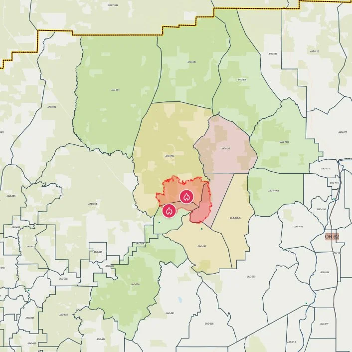
Current evacuation zones surrounding the Evans Creek Road Fire are shown on the Jackson County Sheriff’s Office emergency map Saturday morning. Red marks Level 3, yellow Level 2 and green Level 1 areas. (Jackson County Sheriff’s Office / Genasys Protect)
Jackson County Sheriff’s Office and Emergency Management continue maintaining Level 1, Level 2 and Level 3 evacuation zones.
Level 3: Go Now
JAC-124
JAC-148A
JAC-124 includes the 22705 through 24100 blocks of East Evans Creek Road.
JAC-148A includes residences adjacent to East Evans Creek Road from addresses 19385 through 21899. Residences at 21612 Antioch Road and 21615 Antioch Road are also included.
Residents in Level 3 zones should remain out of the area until officials announce it is safe to return.
Level 2: Be Set
JAC-016
JAC-147
JAC-148B
Level 1: Be Ready
JAC-003
JAC-004
JAC-017
JAC-026
JAC-036
JAC-109
JAC-126
JAC-149B
Residents should continue monitoring official alerts and be prepared for evacuation levels to change.

SHELTER AND LIVESTOCK INFORMATION
An evacuation shelter for residents and domestic pets remains open at:
Hanby Middle School
806 Sixth Avenue
Gold Hill
Horses and other livestock may be taken to:
Jackson County Expo
21 Peninger Road
Central Point
Owners should call 541-776-7206 before arriving to confirm space is available. Officials recommend bringing feed, water containers and necessary medications when possible.
ROAD AND AIRSPACE RESTRICTIONS
East Evans Creek Road remains closed to public traffic at Meadows Road.
Officials are asking people to avoid the fire area so firefighters, emergency vehicles and heavy equipment can operate safely.
A temporary flight restriction remains in effect over the fire 24 hours a day. Flying a drone near a wildfire is illegal and can force firefighting aircraft to suspend operations.
The fire began at approximately 2:41 p.m. Friday after a vehicle crashed into a power pole and ignited dry vegetation. The Jackson County Sheriff’s Office continues investigating the cause of the crash.
Cover image: A North Lincoln Fire & Rescue engine moves toward active fire beneath a smoke-filled sky on the East Evans Creek Fire. Structural crews worked alongside wildland firefighters Monday evening as flames and wind-driven embers threatened homes. (Oregon Department of Forestry)


More Firewatch





ODF Southwest Oregon’s 4 Alpha Fox helicopter has completed its 75-day seasonal contract after introducing approved night-vision wildfire flights this year. One recent after-dark mission located three lightning-caused fires.