
East Evans Creek Fire Reaches 3,628 Acres, 5% Contained
Overnight Crews Reinforce Lines, Build Around 20-Acre Slopover Near Spignet Butte

FAST FIRE FACTS
Name: East Evans Creek Fire
Location: Approximately seven miles west of Shady Cove
Acres: 3,628, based on overnight infrared mapping
Containment: 5%
Personnel: Nearly 1,000 firefighters, support personnel and incident management staff, last reported Sunday night
Fire activity: Continued burning within established control lines near Spignet Butte
Overnight progress: New line connected on the northeast and south; crews built around a roughly 20-acre slopover
Mop-up: Up to 25 feet along portions of the south and east; approximately 100 feet around homes within the fire footprint
Current concerns: Thunderstorms, erratic winds, lightning and possible new fire starts
Evacuations: Level 1, Level 2 and Level 3 zones remain active
Cause: Vehicle crashed into a power pole; the cause of the crash remains under investigation
Updated: Monday morning, July 13
Have fire photos or video? Send them our way.
LATE AFTERNOON UPDATE — JULY 13, 2026
Jackson County officials upgraded evacuation zone JAC-124 to Level 3: Go Now on Monday afternoon. Residents in the 22705 through 24100 blocks of East Evans Creek Road should leave immediately. Jackson County sheriff’s deputies are conducting door-to-door notifications in the area.
Fire activity increased on the north end of the East Evans Creek Fire as hot weather, gusty winds and steep terrain challenged firefighters. ODF reported two separate smoke columns were visible while Type 1, Type 2 and Type 3 helicopters, along with air tankers, attacked the active areas with water and retardant drops.
Ground crews continue fighting the fire and constructing control line. Officials said lines remain holding on the south side along East Evans Creek Road. No updated acreage or containment figure was included in the afternoon report, with additional information expected later Monday evening.
Residents in JAC-124 should not delay to gather belongings or attempt to protect their homes. Officials warned of extreme danger and said emergency responders may not be available to assist anyone who chooses to remain.
East Evans Creek Fire AM update for 7/13/26.
Updated to include the ODF Morning Briefing
An overnight infrared map shows the East Evans Creek Fire at an interpreted 3,628 acres following a flight completed at approximately 11:10 p.m. Sunday. The map identifies areas of intense and scattered heat within the fire perimeter. (Incident Awareness and Assessment)
SAMS VALLEY, Ore. — Firefighters strengthened lines overnight across the East Evans Creek Fire after Sunday’s hot, windy conditions increased activity on the northwestern side of the incident.
The fire remains mapped at 3,628 acres and at the latest reported 5% containment. Oregon Department of Forestry officials said the acreage increase reflects additional burning within established control lines, rather than the fire escaping the overall control area.
Fire continued consuming fuels overnight in steep, difficult-to-access terrain near Spignet Butte, moving toward an indirect line firefighters have been constructing. Crews reinforced fireline, strengthened temporary retardant lines dropped Sunday and built line around a roughly 20-acre slopover.
Firefighters also connected sections of line along the northeastern edge and southern side of the fire, where most threatened homes are located. Mop-up has reached as much as 25 feet inside portions of the southern and eastern perimeter, while structural crews continue working approximately 100 feet around homes within the fire area.
Thunderstorms are possible across Southern Oregon Monday, bringing the risk of erratic winds over the fire and lightning that could ignite additional fires. Level 1, Level 2 and Level 3 evacuation notices remain active.
AIRCRAFT MAKE MORE THAN 20 RETARDANT DROPS
Aircraft played a major role in holding the northwestern portion of the fire Sunday as wind and high temperatures increased fire behavior.
Large Air Tankers and Very Large Air Tankers completed more than 20 retardant drops to reinforce fire lines. Helicopters also dropped water on torching trees and hotspots, slowing the fire’s spread and supporting firefighters working below.
ODF said the combined ground and aerial response successfully defended progress made earlier in the incident.
Overnight crews worked to strengthen and connect the temporary retardant lines established by air tankers during Sunday’s active fire period.
The infrared-mapped perimeter of the East Evans Creek Fire, shown here repositioned over Medford for scale only, covers approximately 3,628 acres, or 5.67 square miles. (Jefferson Firewatch graphic; perimeter based on overnight infrared mapping released July 13, 2026)
OVERNIGHT CREWS BUILD AROUND SLOPOVER
Fire continued burning overnight through fuels in steep and difficult terrain near Spignet Butte on the northwestern edge of the incident.
ODF said the fire moved closer to an indirect line crews have been building in that area. Firefighters spent the night strengthening line and reinforcing the temporary retardant barriers established by air tankers Sunday.
Crews also constructed line around a roughly 20-acre slopover and connected additional sections of fireline along the northeastern edge.


MOP-UP EXPANDS NEAR HOMES
Lines continued to hold along the southern side of the fire, where the majority of threatened residences are located.
Wildland crews have completed up to 25 feet of mop-up along portions of the southern and eastern perimeter. The work involves cooling and extinguishing heat inside the fireline to create a cold, blackened barrier that is less likely to reburn.
Oregon State Fire Marshal crews patrolled neighborhoods near the fire overnight. Structural firefighters will continue mopping up approximately 100 feet around homes within the fire footprint Monday.
Firefighters and incident management personnel from agencies across Oregon gather for a morning briefing on the East Evans Creek Fire as crews prepare for another operational period focused on structure protection and strengthening control lines. (Oregon State Fire Marshal)
A July 13 briefing map shows the latest mapped perimeter of the East Evans Creek Fire, along with division assignments, completed and planned fire lines, access routes, staging areas and water sources. The map lists the fire at 3,152 acres but overnight IR flight mapping has put the fire at 3628 acres. (Oregon Department of Forestry/Oregon State Fire Marshal)
FIREFIGHTERS BUILD DIRECT AND INDIRECT LINE
Wildland firefighters continue constructing line directly along the fire’s edge where terrain and access allow.
In more difficult areas, crews are using indirect line to contain the fire within the smallest practical footprint. Equipment is reopening roads and fire lines from previous fires along the northern perimeter, while hand crews connect those systems with newly constructed line.
Night crews used cooler temperatures and an inversion to strengthen existing lines, watch for fire outside the perimeter and continue mop-up work along the southern portion of the incident.
NEARLY 1,000 PEOPLE SUPPORTING RESPONSE
ODF reported late Sunday that nearly 1,000 firefighters, support personnel and incident management staff were working from the East Evans Creek Fire camp.
No injuries or illnesses had been reported on the incident.
Unified Command includes ODF Incident Management Team 1 and the Oregon State Fire Marshal Blue Incident Management Team.
Pacific Power crews are also supporting the response. The utility is coordinating with incident managers to restore electricity as residents return home and conditions allow crews to work safely.
THUNDERSTORMS COULD BRING ERRATIC WINDS
Forecast instability has increased the possibility of thunderstorms across Southern Oregon Monday.
Storms could create sudden, erratic winds over the East Evans Creek Fire and produce lightning capable of starting new fires. Unified Command said additional resources can be deployed if new incidents are reported.
Firefighters will continue strengthening lines and working to keep the fire within the smallest possible footprint.
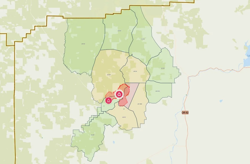
Current evacuation zones surrounding the Evans Creek Road Fire are shown on the Jackson County Sheriff’s Office emergency map Saturday morning. Red marks Level 3, yellow Level 2 and green Level 1 areas. (Jackson County Sheriff’s Office / Genasys Protect)
EVACUATIONS REMAIN
The Jackson County Sheriff’s Office and Jackson County Emergency Management said all evacuation levels will remain in place overnight.
Residents can check whether a specific address is within an evacuation zone through Genasys Protect. Additional fire and evacuation information is available through the Ready Jackson County Emergency Information Hub.
Jackson County Sheriff’s Office and Jackson County Emergency Management evacuation notices remained in effect Saturday evening.
Level 3, Go Now
JAC-148A
This zone includes residences adjacent to East Evans Creek Road from addresses 19385 through 21899. Residences at 21612 Antioch Road and 21615 Antioch Road are also included.
Level 2, Be Set
JAC-016
JAC-124
JAC-147
JAC-148B
Level 1, Be Ready
JAC-003
JAC-004
JAC-017
JAC-026
JAC-036
JAC-109
JAC-126
JAC-149B
Residents within evacuation areas should remain prepared for conditions or evacuation levels to change and continue monitoring official alerts.

SHELTER AND LIVESTOCK INFORMATION
An evacuation shelter for residents and domestic pets remains open at:
Hanby Middle School
806 Sixth Avenue
Gold Hill
Jackson County officials said livestock may be taken to:
Jackson County Expo
21 Peninger Road
Central Point
Owners should call 541-776-7206 before arriving to confirm space is available and should bring feed, water containers and necessary medications when possible.
ROAD AND AIRSPACE RESTRICTIONS
East Evans Creek Road remains closed to public traffic at Meadows Road.
Officials are asking people to avoid the fire area so firefighters and heavy equipment can operate safely.
A temporary flight restriction remains in effect over the incident 24 hours a day. Flying a drone near a wildfire is illegal and can force firefighting aircraft to stop operating.
Cover image: Retardant covers a section of forest along the East Evans Creek Fire as aircraft work the active northwestern flank Sunday. Large and Very Large Air Tankers made more than 20 retardant drops as gusty winds and high temperatures increased fire behavior. (Oregon Department of Forestry)


More Firewatch




ODF Southwest Oregon’s 4 Alpha Fox helicopter has completed its 75-day seasonal contract after introducing approved night-vision wildfire flights this year. One recent after-dark mission located three lightning-caused fires.