
Picture Rock Fire mapped at 1,277 acres, reaches 10% containment
More accurate mapping lowers acreage as evacuations remain in place near Summer Lake
Working the Fireline: Flames burn along a hillside above a staged dozer as crews work to establish fireline on the Picture Rock Fire. Silver Lake Fire District.
FAST FIRE FACTS
Fire:
Picture Rock Fire #313
Location:
Lake County, near Summer Lake and Highway 31
Start Date:
August 16, 2026
Size: 1,625 acres, as per SCOFMP.
Containment: 0%
Fireline:
90% lined; lines held overnight
Evacuations:
Level 3 (GO NOW), Level 2 (Be Set), and Level 1 (Be Ready) evacuation areas remain in effect
Aircraft Used Sunday:
2 Air Attack aircraft
2 lead planes
4 SEATs
2 MAFFS large air tankers
4 VLATs
1 Type 1 helicopter
1 Type 2 helicopter with 11-person helitack crew
Ground Resources:
2 Type 1 hotshot crews
1 Type 2 initial attack crew
12 engines of various types
1 ODF dozer
1 ODF water tender
Additional dozers, water tenders, engines, and an ALS ambulance ordered or arriving Monday
Cause:
Not yet reported
UPDATE 5:15 PM
The Picture Rock Fire is now mapped at 1,277 acres and 10% contained, according to a Sunday afternoon update from the South Central Oregon Fire Management Partnership.
Officials said the decrease from the previously reported 1,625 acres is the result of more accurate mapping and does not represent a reduction in the fire’s footprint.
The Lake County Sheriff’s Office reports Level 1, Level 2, and Level 3 evacuation orders remain in place around the fire. Evacuation levels can change at any time, and residents should continue checking the OEM Raptor evacuation map for the latest information.
SUMMER LAKE, Ore. — Firefighters are continuing to strengthen lines around the Picture Rock Fire in Lake County after the wildfire grew rapidly Sunday, prompting evacuations and a large response from ground crews and aircraft.
The fire is estimated at 1,625 acres as of Monday morning, according to the South Central Oregon Fire Management Partnership. Officials report 90% of the fire is lined, but containment remains at 0%.
Fire officials said lines held overnight and additional resources are headed to the incident Monday.


The Picture Rock Fire was initially reported Sunday afternoon. By 3:09 p.m., officials estimated the fire at approximately 300 acres and were ordering additional ground resources while a significant aviation response moved into the area.
By Sunday night, SCOFMP estimates the size had increased to 1,625 acres.
Evacuations remain in place
Evacuation levels remain in effect for areas surrounding the fire near Highway 31 and Summer Lake.
The Lake County Sheriff’s Office evacuation map shows a Level 3 (GO NOW) area centered along portions of Highway 31 and nearby roads within the immediate fire area.
A larger Level 2 (Be Set) area surrounds much of the Level 3 zone, while Level 1 (Be Ready) areas extend farther from the fire, including areas west of Highway 31 and east along Carlon Lane.
Residents within a Level 3 (GO NOW) evacuation area should leave immediately. Those under Level 2 (Be Set) should be prepared to leave at a moment’s notice, while residents in Level 1 (Be Ready) areas should monitor conditions and prepare for a possible evacuation.
The Lake County Sheriff’s Office said Sunday night that, based on conditions at the time, officials did not anticipate changes to the evacuation levels overnight.
Residents should continue monitoring official information because evacuation levels can change quickly as fire behavior and weather conditions evolve.
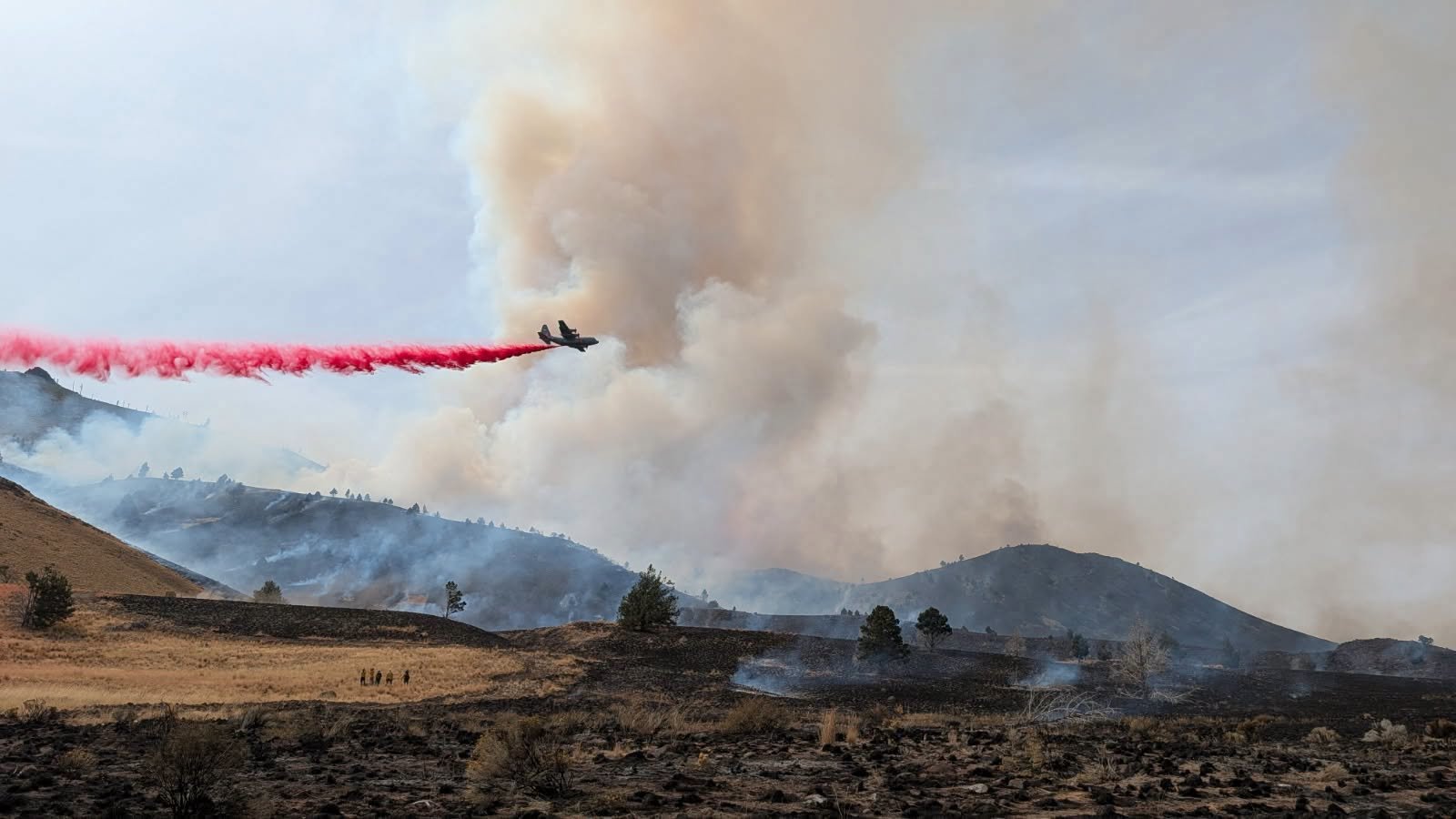
MAFFS Air Attack / Cover Photo: A MAFFS tanker drops retardant along the Picture Rock Fire as smoke rises from the burning hillside in Lake County. South Central Oregon Fire Management Partnership.
Large air attack supports firefighters
Aircraft played a significant role in Sunday’s suppression effort.
SCOFMP reported that the aviation response during the day included two air attack aircraft, two lead planes, four single-engine air tankers, two large air tankers operating as MAFFS aircraft, and four very large air tankers.
A Type 1 helicopter and a Type 2 helicopter with an 11-person helitack crew also supported the incident.
Photos released by fire officials show aircraft dropping retardant along the fire while crews worked on the ground beneath a large smoke column.
Crews Arrive: Firefighters move toward the Picture Rock Fire as crews and apparatus stage below the smoke-covered hillside near Summer Lake. Silver Lake Fire District.
Ground resources continue arriving
Two Type 1 hotshot crews and one Type 2 initial attack crew were on scene Sunday, along with seven local engines from the U.S. Forest Service, Bureau of Land Management, Oregon Department of Forestry, and contract resources.
An ODF dozer and water tender were also working the fire.
Five additional engines were expected to arrive Sunday evening as a task force.
Fire officials said two additional Type 2 water tenders, two Type 2 dozers, and an advanced life support ambulance were expected Monday. Additional ground resources have also been ordered.
An incident command post was being coordinated Sunday night as the response expanded.
Heavy Equipment: Dozers and support equipment arrive at the Picture Rock Fire as firefighters build and strengthen containment lines around the growing incident. Silver Lake Fire District.
Fire remains uncontained
While crews have established line around approximately 90% of the fire, officials continue to report containment at 0%.
Fireline and containment represent different stages of suppression work. A completed line can provide a barrier around a fire, but portions of that line are not considered contained until firefighters determine they are secure enough that the fire is unlikely to escape under expected conditions.

Crews will continue strengthening those lines as additional firefighters and equipment arrive Monday.
The Lake County Sheriff’s Office is directing residents to official fire information from the Lakeview Interagency Fire Center and to Watch Duty for current incident and evacuation information.
Jefferson Firewatch will continue updating the Picture Rock Fire as new acreage, containment, evacuation, and operational information becomes available.


Keep Reading




