
Crews Complete Line Around Active Board Mountain Area as East Evans Creek Fire Reaches 15,015 Acres
Firefighters reinforce the southern perimeter overnight as the fire enters its 10th day and hot, dry conditions remain a concern

FAST FIRE FACTS
Name: East Evans Creek Fire
Location: About 7 miles west of Shady Cove
Acres: 15,015
Containment: 8%
Evacuations: Level 1, 2 and 3 remain in effect
Current Focus: Board Mountain south of Boswell Mountain
Fire Activity: Main fire lines holding; mop-up continues
Weather: Hotter afternoon conditions with increasing winds
Cause: Vehicle crash into a power pole
Latest Maps: View current fire maps
East Evans Creek Fire AM update for 7/20/26 - Day 10
The July 20 Operations Map shows the East Evans Creek Fire at 15,015 acres, including the main fire and associated spot-fire perimeters extending east toward Board Mountain and Boswell Mountain. For the second night, no new infrared flight was completed due to limited resources, but updated official perimeter mapping was released Monday morning. View all current maps on the East Evans Creek Fire Maps page. (Oregon Department of Forestry)
SAMS VALLEY, Ore. — The East Evans Creek Fire entered its 10th day Monday at 15,015 acres, with firefighters reporting overnight progress across the incident, including completed fireline around the active portion of the Board Mountain spot fire.
Crews pushed mop-up deeper into burned areas, strengthened control lines and reinforced portions of the Board Mountain perimeter where fire crossed established lines during increased activity Sunday.
No infrared mapping flight was completed overnight, but updated operations mapping released Monday morning places the fire at 15,015 acres, an increase of 573 acres from the 14,442-acre perimeter mapped Sunday morning.
Containment remains 8% based on the latest reported figure.
Across the main fire, control lines held overnight, while crews continued focusing resources on the southern portion of the Board Mountain spot fire south of Boswell Mountain.
Fire officials said extensive structure preparation and protection work has been completed around threatened communities, although engines and other resources remain positioned near homes as dry vegetation, persistent heat and shifting winds continue to create the potential for renewed fire activity.
CREWS REINFORCE BOARD MOUNTAIN LINES
The Board Mountain spot fire remains a major operational focus.
Overnight crews strengthened existing control lines, including the southwestern edge where fire crossed the line Sunday.
Firefighters concentrated on the southern portion south of Boswell Mountain, reinforcing the perimeter and limiting additional spread.


Monday’s operations will continue to surge resources into that area. Crews will improve fireline, deepen mop-up and remove hazardous trees that could threaten firefighters working below.
Aircraft will coordinate with ground crews on the southeast side of the Board Mountain spot fire, where firefighters and initial bulldozer line stopped forward movement overnight.
Structural resources remain positioned near homes in the Antioch, Jones Road and Pomeroy areas.
Firefighters monitor active flames from inside a fire apparatus during nighttime operations on the East Evans Creek Fire. (Rural Metro Fire)
MAIN FIRE LINES HOLD OVERNIGHT
Control lines around the main East Evans Creek Fire held overnight as crews continued pushing mop-up farther inside the perimeter.
Firefighters are extending hose lays to reach deeper pockets of heat and reduce the chance that remaining fire could threaten established control lines.
Dry vegetation and persistent heat continue to create elevated spotting potential, keeping crews alert even in areas where the perimeter has remained stable.
Resources working more secure portions of the incident remain available to reposition if activity increases elsewhere or to assist local agencies with new fire starts.
CANYON CREEK REMAINS WITHIN ITS FOOTPRINT
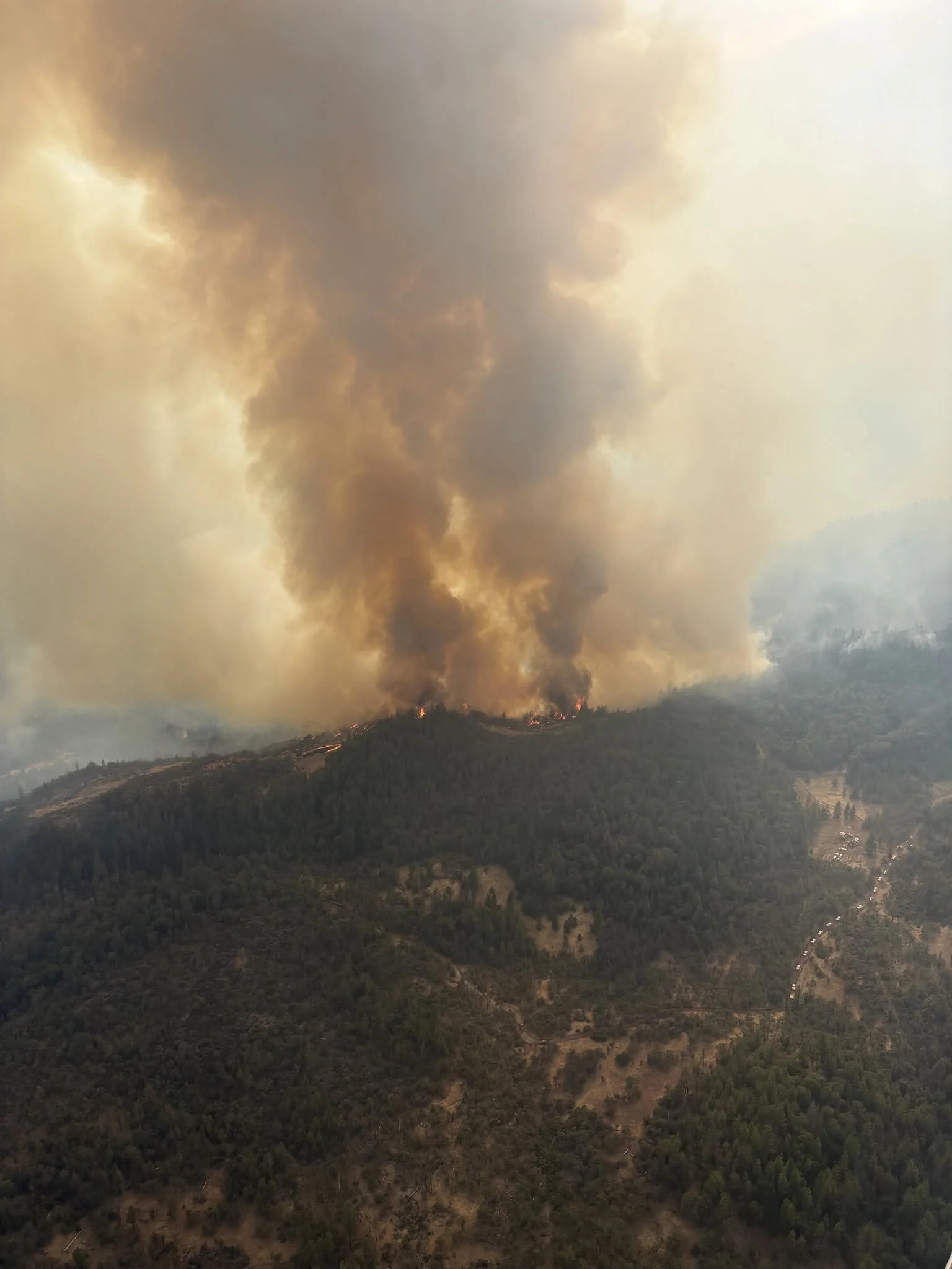
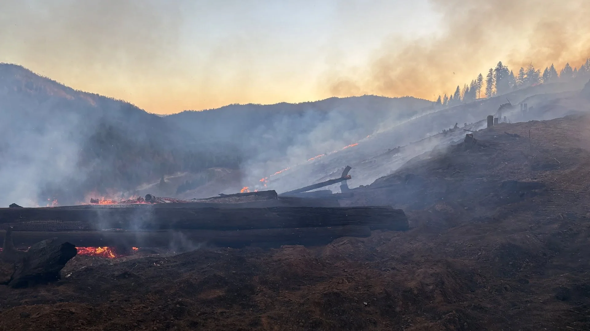
A large smoke column rises above active fire burning across steep terrain on the East Evans Creek Fire during recent suppression operations. (Oregon Department of Forestry)
The Canyon Creek spot fire remained within its existing footprint overnight after firefighters quickly contained a small slopover Sunday.
Crews continue working immediately inside the fireline to cool remaining heat and strengthen the perimeter.
Structure protection resources remain positioned throughout Shady Cove, Trail, Long Branch, Dry Creek and other nearby communities as part of a proactive protection strategy.
HULL MOUNTAIN WORK CONTINUES
Northwest of Hull Mountain, firefighters continue securing the perimeter and extending hose to support deeper mop-up operations.
Crews are working in steep terrain to strengthen line and eliminate remaining heat near containment features.
Structural resources also remain in the Ramsey Canyon Road area, where high-capacity pumps are helping increase water delivery for wildland firefighters.
STRUCTURE PROTECTION REMAINS IN PLACE
Although extensive preparation around threatened communities has been completed, structural resources are not leaving those areas.
Crews continued patrolling near homes overnight, checking for hot spots and supporting suppression operations where needed.
Resources remain positioned in and around Shady Cove, Trail, Canyon Road, Dry Creek, Antioch, Jones Road, Pomeroy and other nearby areas.
The strategy allows crews to respond quickly if wind-driven embers or changing fire behavior threaten homes.
Firefighters coordinate nighttime suppression operations as active fire burns along a ridge on the East Evans Creek Fire. (Rural Metro Fire)
COOLER MORNING, HOTTER AFTERNOON EXPECTED
An incident meteorologist remains assigned to the fire and is monitoring cloud cover, the morning inversion and changing weather conditions.
Monday morning brought cooler temperatures and isolated showers in some areas, but those conditions are not expected to last.
Temperatures could climb into the mid- to upper 90s, with winds increasing again during the afternoon.

Dry fuels, steep terrain and shifting winds remain capable of challenging containment lines, while spotting potential remains elevated.
Cloud cover could also delay the lifting of the inversion and affect when aircraft are able to operate safely.
Firefighters enter Monday with stronger lines and the benefit of overnight cooling, but officials said crews remain prepared for activity to increase as conditions change later in the day.
LATEST FIRE MAPS
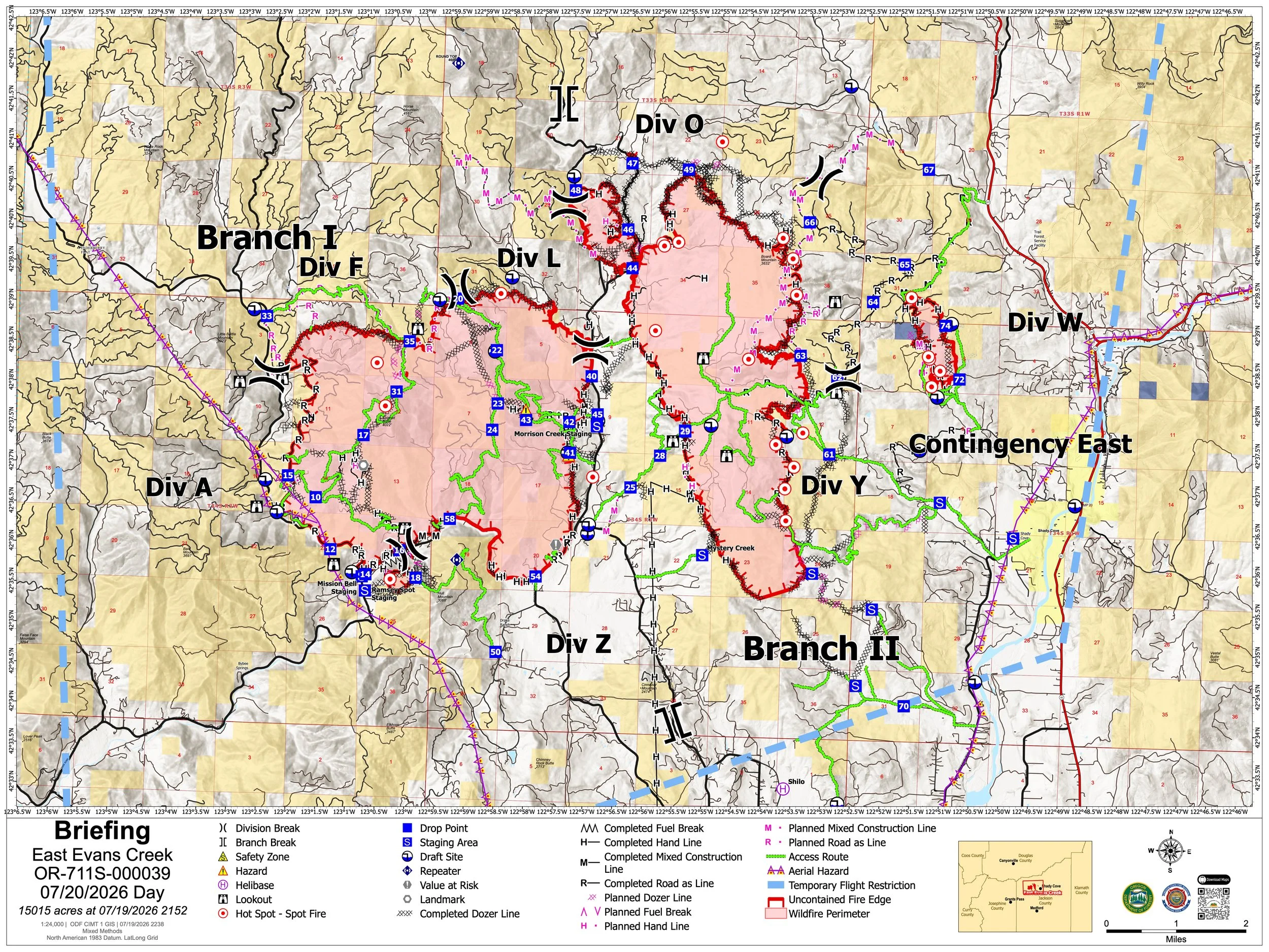
The July 20 Briefing Map shows the East Evans Creek Fire at 15,015 acres, including the main fire and associated spot-fire perimeters extending east toward Board Mountain and Boswell Mountain. For the second night, no new infrared flight was completed due to limited resources, but updated official perimeter mapping was released Monday morning. View all current maps on the East Evans Creek Fire Maps page. (Oregon Department of Forestry)
The latest official public information map released Sunday places the East Evans Creek Fire at 15,015 acres.
No new infrared flight was completed this weekend because increased wildfire activity across Oregon has increased demand for aviation resources.
The current maps show the main fire and associated spot-fire areas extending east toward Board Mountain, Boswell Mountain and Canyon Creek.
Fire activity has continued to change since portions of the available mapping were produced, particularly around Board Mountain, where firefighters dealt with multiple areas crossing control lines over the weekend.
Readers should use maps as a reference to the overall fire footprint rather than a real-time representation of active flames.
View the complete collection of current public information, infrared, operations and briefing maps on the East Evans Creek Fire Maps page.
Fire Weather
Firefighters could face another challenging afternoon Monday despite cooler conditions and isolated showers during the morning.
An incident meteorologist is monitoring cloud cover and the inversion, which could remain in place longer and delay aviation operations.
Conditions expected later Monday include:
Temperatures reaching the mid- to upper 90s
Increasing afternoon winds
Very dry vegetation
Elevated spotting potential
Shifting winds capable of testing containment lines
Overnight cooling and improved humidity helped firefighters strengthen lines, but critically dry fuels remain receptive to embers.
Smoke may continue settling into valleys and other low-lying areas, reducing visibility and affecting air quality.
The July 20 smoke outlook forecasts generally good to moderate air quality across much of Southern Oregon, with heavier smoke possible near Shady Cove and other areas directly affected by the East Evans Creek Fire plume. (Interagency Wildland Fire Air Quality Response Program) Click to enlarge
FIRE DANGER

Extreme fire danger remains in effect on Oregon Department of Forestry-protected lands across Jackson and Josephine counties. The Industrial Fire Precaution Level remains at Level 2.
Activities prohibited under Extreme fire danger include:
Using power saws, including battery- and electric-powered chainsaws
Cutting, grinding or welding metal
Mowing dried or cured grass
Operating other spark-emitting internal-combustion equipment
Mowing green, irrigated lawns and agricultural harvesting remain exempt.
Debris burning, fireworks, tracer ammunition and exploding targets remain prohibited. Campfires and charcoal fires are allowed only in designated campgrounds.
ODF urges residents and visitors to use extreme caution with anything that could start a fire and immediately report new fires by calling 911.
EVACUATION LEVELS
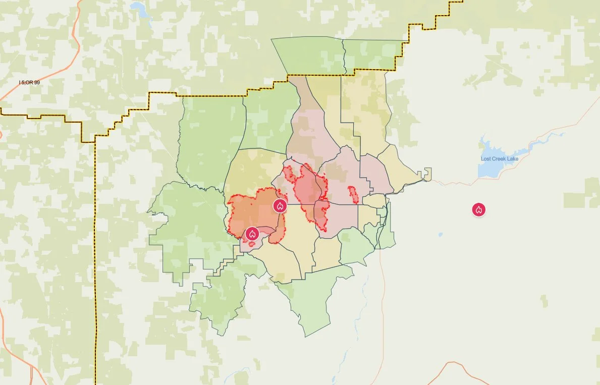
The latest evacuation map showing level 1, 2, and 3 evacuations due to the East Evans Creek Fire. Residents should use the interactive Genasys map to check current conditions for a specific address. (Project Genasys)
Level 1, Level 2 and Level 3 evacuation notices remain active in portions of Jackson and Douglas counties.
The Jackson County Sheriff’s Office upgraded evacuation levels Saturday evening as fire activity increased.
Because evacuation zones can change rapidly, residents should rely on the most recent county alerts and live evacuation mapping for their current status.
Level 3, Go: means leave immediately.
Level 2, Set: means be prepared to leave at a moment’s notice.
Level 1, Ready: means remain alert, prepare your belongings and be ready for conditions to change.
Check your current evacuation zone and live evacuation map.
Level 3: Go Now
JAC-017
JAC-109
JAC-124
JAC-126
JAC-149B
Residents in Level 3 zones should remain out of the area until officials announce it is safe to return.
Level 2: Be Set
JAC-016
JAC-026
JAC-111
JAC-112
JAC-127
JAC-131
JAC-132
JAC-133
JAC-134
JAC-147
JAC-148
JAC-149A
JAC-203B
Level 1: Be Ready
JAC-003
JAC-004
JAC-014
JAC-036
JAC-158
JAC-203A
DOU-1012
DOU-1015
SHC-151
SHC-152
SHC-153
SHC-154
SHC-156
SHC-157
SHC-158
The SHC zones place Shady Cove under a Level 1: Be Ready notice.
Evacuation levels and boundaries may change as conditions develop. Residents should continue monitoring county alerts and verify their address through the official evacuation map.
EVACUATION SHELTER
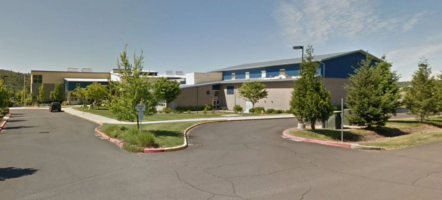
Eagle Point Middle School at 477 Reese Creek Road is serving as the evacuation shelter for residents and domestic pets affected by the East Evans Creek Fire. (Google Street View)
The evacuation shelter for residents and domestic pets remains open at:
Eagle Point Middle School
477 Reese Creek Road, Eagle Point, OR 97524
Pets are welcome on the shelter property but cannot enter the school building. The American Red Cross has established a designated area for domestic pets.
Livestock sheltering remains available through the Jackson County Expo:
Jackson County Expo
21 Peninger Road, Central Point
Owners should call 541-776-7206 before arriving to confirm space is available. The same number may be used for medical or livestock sheltering assistance.
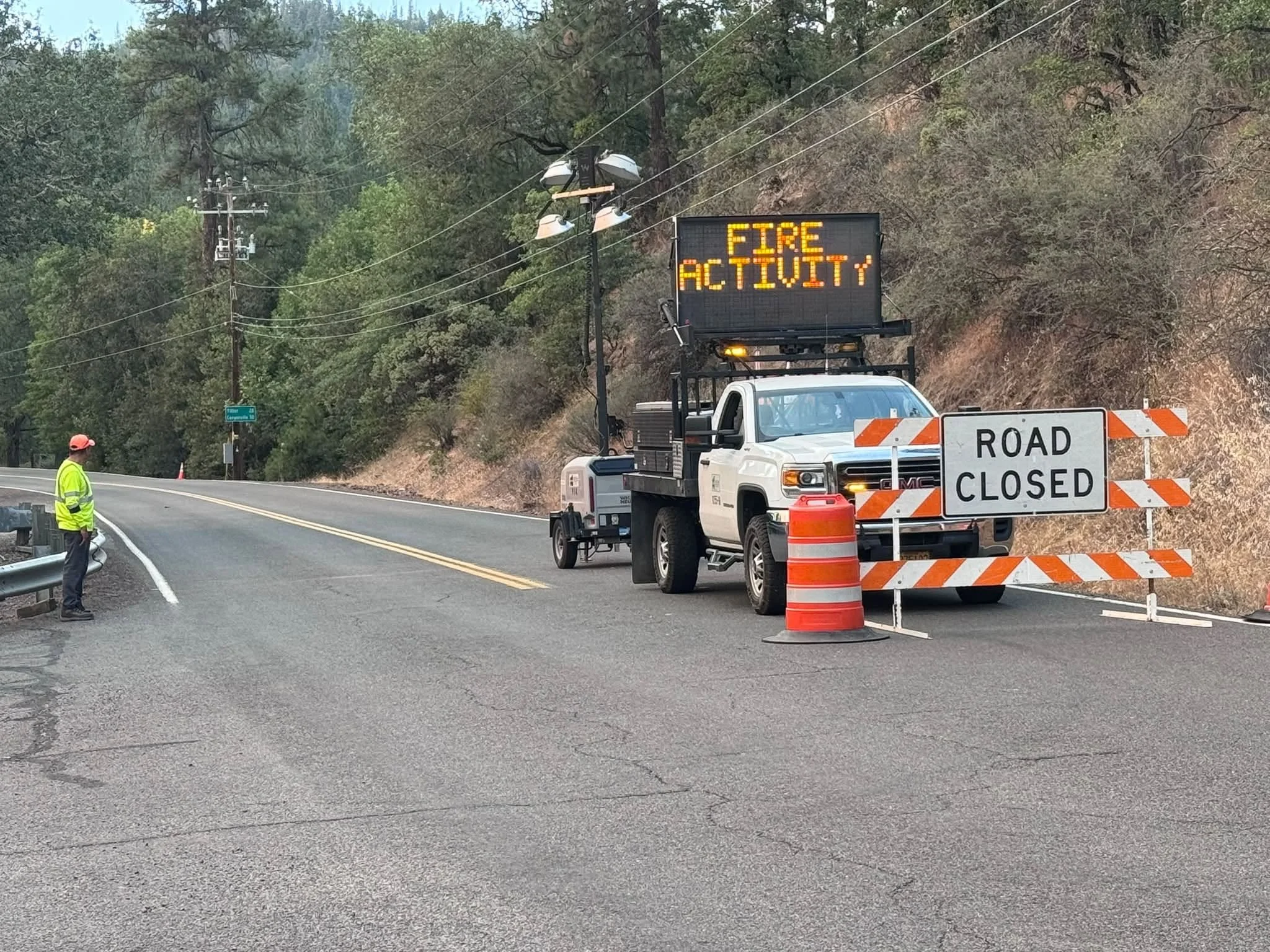
A Jackson County Roads employee staffs a closure as an electronic sign warns drivers of nearby fire activity. (Courtesy Jackson County Parks)
CLOSURES
The following closures remain in effect:
Tiller-Trail Highway from the Jackson County line to Highway 62
East Evans Creek Road at Meadows Road
West Fork Evans Creek Road
Rock Creek Road
Rogue Elk Park, including the campground, day-use area and boat ramp
Dodge Bridge Boat Ramp, currently used as a firefighting water-supply site
BLM-administered lands near the fire remain closed to public entry, including hunting, hiking and camping.
A 24-hour Temporary Flight Restriction remains in effect over the fire. Flying a drone near the incident is illegal and may force firefighting aircraft to stop operating.
Cover photo: A Woodburn Fire District water tender moves through fire camp beneath a smoke-filled sunset while supporting water delivery operations on the East Evans Creek Fire. (Oregon Department of Forestry)


More Firewatch




ODF Southwest Oregon’s 4 Alpha Fox helicopter has completed its 75-day seasonal contract after introducing approved night-vision wildfire flights this year. One recent after-dark mission located three lightning-caused fires.