
Level 3 Evacuations Issued as Wrights Spring Fire Surges to 8,722 Acres
OREGON MOBILIZES ADDITIONAL RESOURCES AS THE FIRE REACHES SADDLE MOUNTAIN, THREATENS PRIVATE PROPERTY, AND PROMPTS EVACUATIONS NEAR SPRAGUE RIVER.
FAST FIRE FACTS
Name: Wrights Spring Fire
Location: East of Chiloquin and south of Sprague River in the Fremont-Winema National Forest
Acres: Approximately 8,722
Containment: 0%
Evacuations: Level 1, Level 2, and Level 3 zones remain in effect around the fire and Sprague River area
Command: Northwest Team 8 and OSFM Green Incident Management Team in unified command
Resources: Six OSFM structural task forces, with additional handcrews, engines, dozers, task forces, and other resources arriving
Activity: Fire growth occurred on all sides overnight, including several thousand acres on the east flank. The fire is established at the west base of Saddle Mountain, with spot fires ahead of the main fire and movement toward private property
Shelter: Chiloquin Elementary School, 548 S. 2nd Ave.
Large Animals: Klamath County Fairgrounds for horses; cattle assistance through Southern Oregon Emergency Aid at 831-235-3031
Spring Creek / Cover Image: The Wrights Spring Fire builds a large smoke column as seen from Spring Creek near Chiloquin. Have a photo of the fire from your area? Share it with Jefferson Firewatch. Photo by Jenn Archibald.
Updated, 6:10pm
CHILOQUIN, Ore. — The Wrights Spring Fire remains mapped at approximately 8,722 acres and 0% containment Friday evening as Level 1, Level 2, and Level 3 evacuations remain in effect east of Chiloquin and around the Sprague River area.
The fire experienced growth on all sides overnight, including several thousand acres along the east flank. Officials say the fire has established along the west base of Saddle Mountain, with spot fires burning ahead of the main fire and suppression crews working as the incident moves toward private property.
Evacuation Areas: The Genasys Protect map shows updated Level 3 “GO NOW,” Level 2 “Be Set,” and Level 1 “Be Ready” zones surrounding the Wrights Spring Fire. Genasys Protect.


Current Evacuations
Level 3 “GO NOW” evacuation orders are in effect for FHZ-1166, FHZ-1581, FHZ-1582, KLA-1162, KLA-1163, KLA-1164, KLA-1165, KLA-1167, KLA-1168, and KLA-1376.
Level 2 “Be Set” notices are in effect for KLA-1156, KLA-1161, and KLA-1381.
Level 1 “Be Ready” notices are in effect for KLA-1031, KLA-1171, KLA-1176, KLA-1361, KLA-1366, KLA-1371, KLA-1391, and KLA-1401.
Evacuation boundaries have changed several times Friday. Residents near the fire should check their specific address through Genasys Protect and continue monitoring Klamath County emergency alerts for changes.
Hamaker View: Smoke from the Wrights Spring Fire builds over the landscape east of Chiloquin as seen from the Hamaker camera. AlertWest, Oregon Hazards Lab, University of Oregon.
Fire Activity
SCOFMP says exceptionally dry fuels, high temperatures, and low relative humidity are contributing to active and erratic fire behavior.
The fire has become established along the west base of Saddle Mountain in the Badlands area west of Sprague River. Spot fires have been identified ahead of the main fire on Saddle Mountain, where continuous vegetation and dense underbrush beneath tree plantations could support additional spread.
Crews made progress along the northern perimeter and continued securing Forest Service Road 5817 west of the fire. Limited road access on the south and east flanks is making it difficult for equipment to establish fire breaks.
Officials say the fire is moving toward private property.
Unified Command
Northwest Team 8, a Complex Incident Management Team, assumed command of the Wrights Spring Fire at 9 a.m. Friday.
The incident entered unified command with the Oregon State Fire Marshal Green Incident Management Team at 2 p.m. The state response follows Friday morning’s invocation of the Oregon Emergency Conflagration Act.
Six OSFM structural task forces are assigned to the incident. Additional task forces, handcrews, engines, dozers, and other resources have been ordered and are being brought into the fire as they become available.
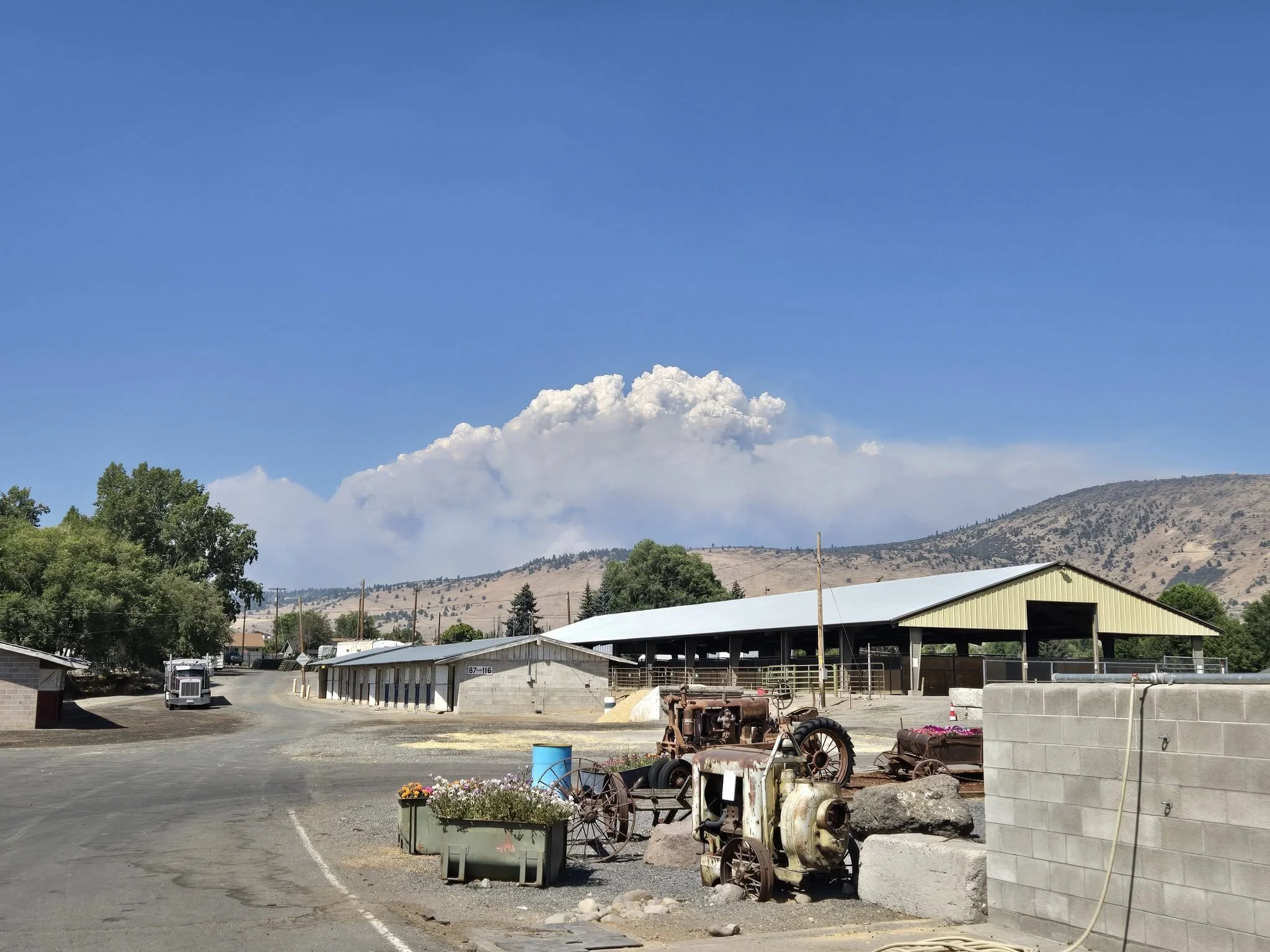
Smoke Plume: A large smoke column from the Wrights Spring Fire rises behind the Klamath County Fairgrounds as suppression operations continue east of Chiloquin. South Central Oregon Fire Management Partnership.
Evacuation Shelter and Animals
A Red Cross emergency shelter is open at Chiloquin Elementary School, 548 S. 2nd Ave., Chiloquin.
The Klamath County Fairgrounds is serving as a large animal shelter for horses.
People needing shelter assistance for cattle can contact Maria Meister with Southern Oregon Emergency Aid at 831-235-3031.
Dozer Operator Killed
The Klamath County Sheriff’s Office confirmed Friday that 47-year-old Jason Ensign of Klamath Falls was killed while operating a Caterpillar D-6 dozer during firefighting operations near Yahwee Plateau.
Officials said rapid fire growth associated with a weather event cut off Ensign’s escape route to a safety zone. A separate Jefferson Daily News report provides additional details on the fatality.

Roads and Public Access
No road or highway closures are currently in effect, according to SCOFMP.
The public is being asked to avoid Forest Service roads 5813, 5817, and 22, also known as Switchback Road, because of heavy fire traffic and ongoing suppression activity.
Fire officials say keeping the public away from active operations is important for both firefighter and public safety.
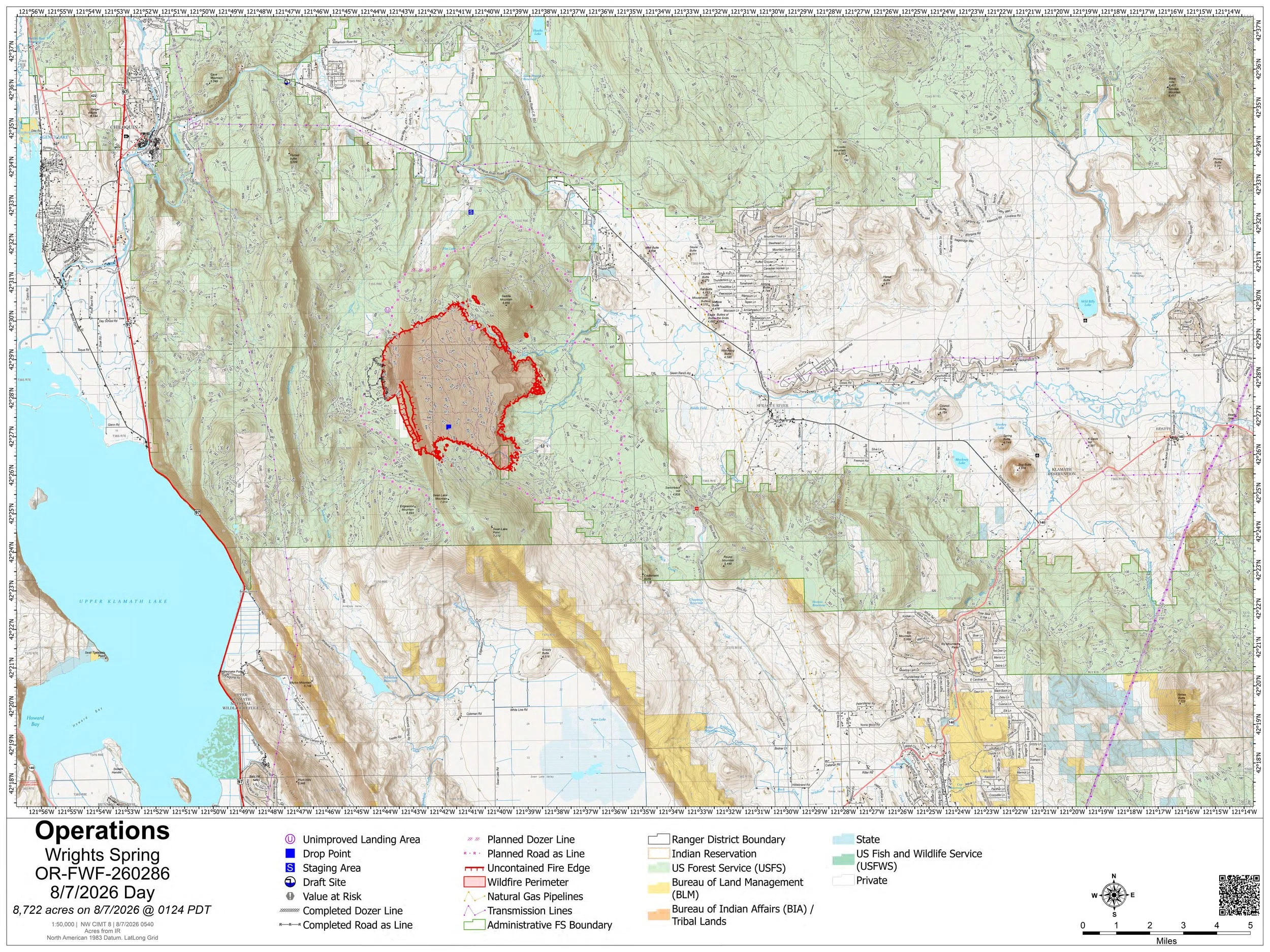
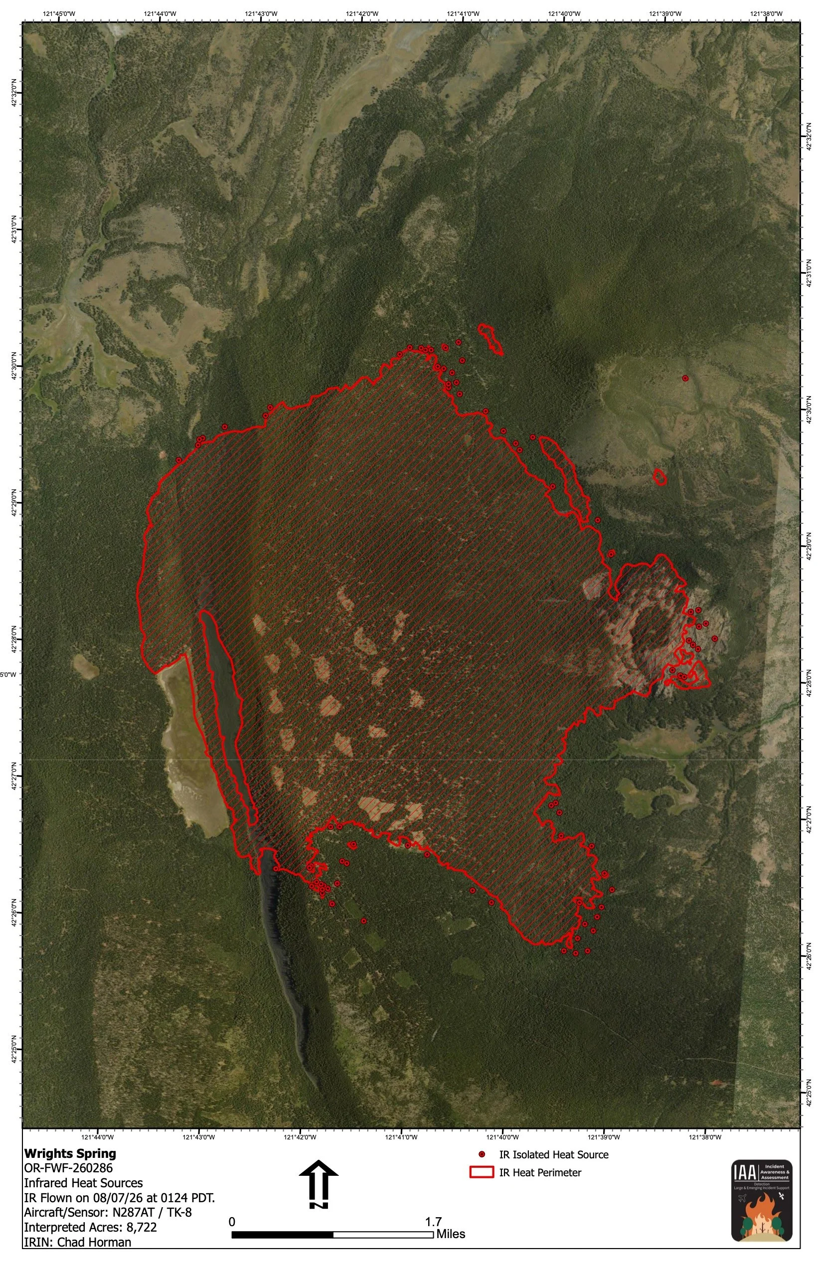
Latest Fire Mapping
An overnight infrared flight mapped the Wrights Spring Fire at approximately 8,722 acres early Friday morning. The infrared map shows the interpreted heat perimeter along with isolated heat sources around the incident.
The latest operations map shows the expanded fire footprint east of Upper Klamath Lake, along with planned and completed fire lines, staging areas, roads, and surrounding land ownership.
The Wrights Spring Fire was first reported Wednesday afternoon in the Fremont-Winema National Forest south of Sprague River Highway and east of Chiloquin. The cause remains under investigation.

Keep Reading




