
Wrights Spring Fire Crosses Bliss Road as Crews Battle Eastward Spread (UPDATED)
Ten task forces protect communities as near critical fire weather continues.
Fire Facts
Name:
Wrights Spring Fire
Location:
About 2 miles west of Sprague River, Oregon
Acres: 33,970
Containment: 0%
Personnel: 434
Evacuations:
35, Level 3 zones
23, Level 2 zones
29, Level 1 zones
Command:
Northwest Team 8 and OSFM Green Team, Unified Command
Activity:
The fire has crossed Bliss Road near Round Mountain. Crews are working to slow further eastward spread and protect structures around Sprague River.
Evacuation Impact: The Oregon Department of Emergency Management estimates 3,144 people and 1,255 addresses are within current evacuation boundaries, including 1,099 people and 440 addresses in Level 3 (GO NOW) areas. Oregon Department of Emergency Management.
UPDATE, 4:40 PM
Fire activity on the Wrights Spring Fire has increased this afternoon, with three distinct smoke columns visible as evacuation boundaries expand again across southern Klamath County.
The latest evacuation information now lists 35 Level 3 (Go Now) zones, 23 Level 2 (Be Set) zones, and 29 Level 1 (Be Ready) zones, creating a broad evacuation footprint extending well beyond the immediate fire area.
Evacuation boundaries continue to change as fire activity develops. Residents should check their current evacuation status on the Jefferson Firewatch evacuation page, which includes the latest Genasys Protect map.
CHILOQUIN, Ore. — The Wrights Spring Fire is mapped at 33,970 acres and remains 0% contained Sunday as firefighters work to slow continued eastward movement and protect communities around Sprague River.
Personnel assigned to the incident have increased to 434, with 10 structural task forces working across the fire Sunday. Fire officials say the fire was very active Saturday and overnight, moving east and southeast and crossing Bliss Road near Round Mountain.
The latest infrared mapping shows a substantially expanded fire perimeter extending from the original fire area east toward Sprague River and southeast into the Round Mountain area.


Crews work to slow eastward spread by establishing an anchor point along Bliss Road and work north with dozers toward Skeen Ranch Road in an effort to stop further eastward movement.
To the north, crews are preparing roads for possible strategic burning operations near Flat Lake.
Fire officials say crews are also scouting between Saddle Mountain and Skeen Ranch Road to determine where the fire crossed the Sprague River and Sprague River Road. The road and river had been identified as control features, and firefighters will work to secure and reestablish those lines.
Fire Operations: A firefighter directs a heavy vehicle during operations on the Wrights Spring Fire as crews and equipment move through the incident area. Photo by Christopher Trotchie.
STRUCTURE PROTECTION EXPANDS
Ten Oregon State Fire Marshal structural task forces are working across the Wrights Spring Fire on day, swing, and night shifts.
Structure protection remains divided into East and West groups.
The West Group is focusing on the Elde area, Saddle Mountain, and areas west of Watchdog Butte, where crews are assessing and preparing structures.
The East Group is working around Skeen Ranch Road and Bliss Road, including areas where fire has already affected property near structures.
Crews are also continuing along Sprague River Road toward Highway 140, assessing structures and preparing for the possibility of additional eastward fire movement.
Additional resources are being positioned around Skeen Ranch Road and Bliss Road for point protection, particularly during the mid to late afternoon when increased fire behavior is expected.
Fire officials say crews are also scouting toward the Bly Mountain area.
Residents may see increased fire activity from Peter Steiner Road north toward Round Mountain.
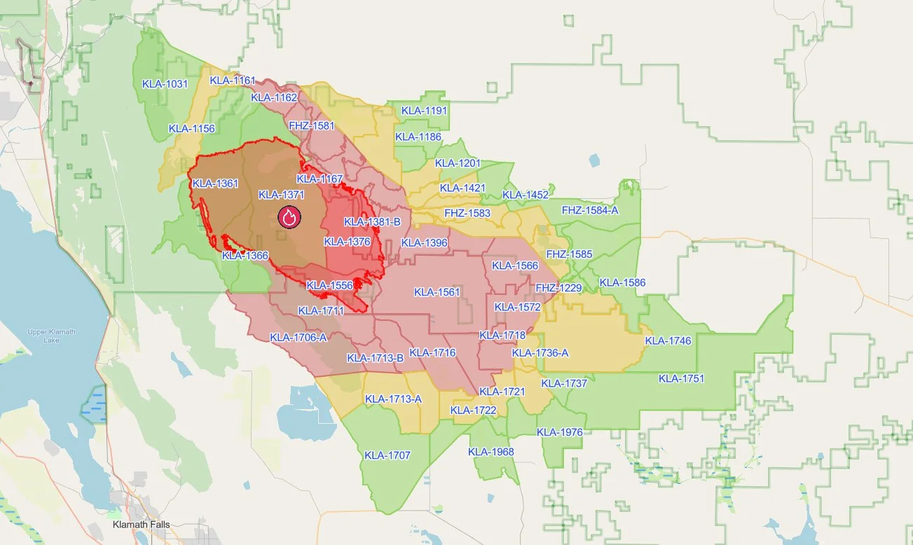
Evacuation Areas: Updated evacuation zones surrounding the Wrights Spring Fire extend from areas east of Chiloquin through Sprague River and farther southeast as the fire continues to expand. Genasys Protect.
EVACUATIONS CONTINUE TO CHANGE
Level 1, Level 2, and Level 3 evacuation notices remain in effect around the Wrights Spring Fire and Sprague River area.
Because evacuation boundaries have changed repeatedly, residents should check their specific address through Genasys Protect rather than relying on an earlier map or social media post.
A Red Cross emergency shelter for people and small animals remains open at Chiloquin Elementary School, 548 S. 2nd Ave., Chiloquin.
A second Red Cross shelter is now open at Living Springs Fellowship, 31897 Mission St., Bonanza.
The Klamath County Fairgrounds remains available for horses only. People needing shelter assistance for cattle can contact Maria Meister with Southern Oregon Emergency Aid at 831-235-3031.
Squaw Flat Store / Cover Image: An orange glow from the Wrights Spring Fire fills the sky behind Squaw Flat Store as residents watch the fire’s activity nearby. Photo by Christopher Trotchie.
Smoke Outlook: Smoke impacts are expected to increase around Klamath Falls and areas east and southeast of the Wrights Spring Fire. Interagency Wildland Fire Air Quality Response Program.
NEAR CRITICAL FIRE WEATHER
Warm, very dry, and breezy conditions are expected Sunday and Monday.
Temperatures are expected to reach the mid 80s on ridges and the low 90s in valleys, with relative humidity falling to between 12% and 16%.
Fire officials are preparing for another significant day of fire activity, particularly during the afternoon.
The latest smoke outlook indicates much of western Southern Oregon should see relatively good air quality, while smoke impacts increase closer to and east of the Wrights Spring Fire. Klamath Falls could see periods of degraded air quality, with greater smoke impacts possible east and southeast of the city.

CLOSURES & RESTRICTIONS
Sprague River Road is closed from milepost 9 to Sprague River Drive.
Bliss Road is also closed from Peter Steiner Road to Sprague River.
Fire officials are asking the public to avoid unnecessary travel around the incident because of heavy firefighting traffic and ongoing suppression operations.
A Temporary Flight Restriction remains in effect over the Wrights Spring Fire.
Recreational drones are prohibited around the fire because they can interfere with firefighting aircraft and potentially force aerial suppression operations to stop.
The Wrights Spring Fire was detected Aug. 5 in the Fremont Winema National Forest. Its cause remains under investigation.


Keep Reading




