
Light rain is expected in parts of Northern California and along the Oregon Coast, with warmer conditions later this week.
FORECAST
Period: November 3–9, 2026
Tuesday: Light rain possible in Northern California, especially Siskiyou and Modoc counties.
Wednesday: Showers developing along the Oregon Coast and into Douglas County. Generally a trace to 0.20 inches.
Western Valleys: Highs in the 50s to lower 60s, warming into the upper 60s by Saturday.
Mountains: Snow levels around 6,000–7,000 feet Wednesday night; little accumulation expected.
Klamath Basin: Mostly dry with highs in the 40s and lower 50s. Overnight lows in the 20s and 30s.
Weekend: Warmer and drier Saturday, with another chance of rain Sunday.
MEDFORD, Ore. — Two weather systems are expected to bring periods of light rain to portions of Southern Oregon and Northern California Tuesday and Wednesday, November 3–4, as the region begins the month with seasonable temperatures and a series of relatively weak Pacific weather systems.
According to the National Weather Service in Medford, the first system will move into Northern California Tuesday afternoon, bringing the greatest chance of precipitation to Siskiyou and Modoc counties.
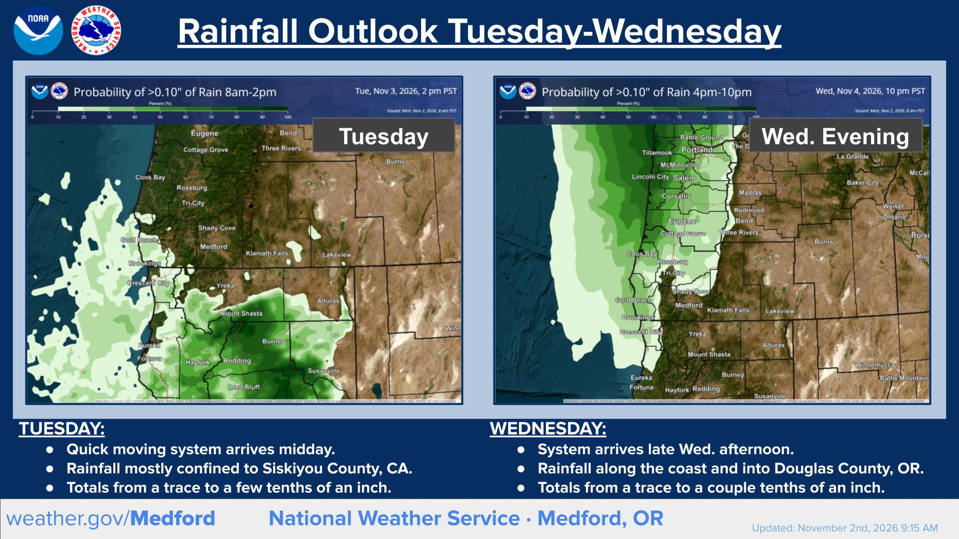
Rainfall Outlook for November 3–4: National Weather Service forecasts show light rain moving into Northern California on Tuesday, followed by another system bringing showers to the Oregon Coast and Umpqua Valley Wednesday evening. Rainfall totals are expected to range from a trace to a few tenths of an inch. Graphic: National Weather Service Medford.
Rain chances range from approximately 40% to 60% in those areas, with rainfall amounts generally expected to remain light. Farther north, precipitation chances are considerably lower across much of Southern Oregon.
A second system will arrive Wednesday afternoon and evening, bringing light rain to the Oregon Coast and portions of Douglas County, including the Umpqua Valley. Rainfall totals are expected to range from a trace to a couple tenths of an inch in affected areas.
Neither system is expected to produce widespread heavy rainfall, although conditions will vary across the region.
REGIONAL FORECAST: NOVEMBER 3–9
Oregon Coast
Coastal communities, including Brookings, Gold Beach, and Coos Bay, can expect relatively quiet weather Tuesday before a weakening cold front approaches Wednesday afternoon and evening.
Light rain is expected along portions of the coast Wednesday night, with the greatest rainfall chances generally north of Brookings.
Conditions should improve Thursday, although another weak system could bring additional showers to portions of Coos and Douglas counties Friday.
Saturday is expected to be comparatively dry before another front approaches late Saturday into Sunday, bringing renewed rain chances.
Ocean conditions will remain unsettled at times, with periods of elevated swells and hazardous seas possible. Beachgoers and mariners should monitor current coastal forecasts and advisories.
Cover Photo / Autumn in Ashland: Fall colors surround a traditional stone lantern in the Ashland Japanese Garden at Lithia Park in Ashland, Oregon. The region faces periods of light rain this week, followed by warmer conditions heading into the weekend. Photo: Brian Gailey / Jefferson Daily News, November 2, 2024 (file photo).
Western Valleys
The Rogue, Illinois, and Umpqua valleys should experience seasonable temperatures through midweek, with afternoon highs generally in the 50s to lower 60s.
Medford, Ashland, and Grants Pass have relatively low chances of rain Tuesday, while Roseburg and the Umpqua Valley have a better opportunity for light precipitation Wednesday evening and overnight.
Areas of morning fog or low clouds are possible, particularly in the Umpqua Valley and portions of the Rogue Valley.
Temperatures should gradually warm Thursday through Saturday, with some western valleys approaching the upper 60s by the weekend.
Another cold front arriving Saturday night into Sunday could bring a more widespread opportunity for measurable rainfall west of the Cascades.
Cascade and Siskiyou Mountains
Mountain areas will experience variable cloud cover and occasional precipitation chances as the weak systems pass through the region.
Snow levels Wednesday night are expected to remain around 6,000 to 7,000 feet, allowing light snow or a rain-and-snow mix at higher elevations.
Significant snowfall is not anticipated from the midweek system, and lower mountain passes are more likely to experience rain where precipitation develops.
Conditions should become milder toward Saturday, followed by another opportunity for precipitation as a weekend system moves inland.
Travelers should continue monitoring mountain forecasts, particularly when crossing higher-elevation routes overnight.
Klamath Basin and Lake County
Klamath Falls, Chiloquin, Lakeview, and surrounding communities should remain mostly dry Tuesday, with only a slight chance of precipitation in some areas.
Daytime temperatures will generally range from the mid-40s to lower 50s early in the week, while overnight lows could fall into the 20s and 30s.
Another slight chance of rain develops Wednesday night, particularly across northern Klamath County, with light snow possible at higher elevations.
Temperatures should gradually moderate toward Saturday before another weak weather system approaches late in the weekend.
Northern California
Siskiyou and Modoc counties have the region's greatest likelihood of precipitation Tuesday as the first weather system moves inland.
Rain chances are generally around 40% to 60%, with light accumulations expected across affected areas. Communities around Mount Shasta and portions of eastern Siskiyou and Modoc counties could see showers during the afternoon and evening.
Snow levels near 6,000 feet could allow a rain-and-snow mix at higher elevations, although little accumulation is expected.
Conditions should become drier Wednesday, followed by a warming trend Thursday through Saturday.
Additional precipitation remains possible later in the weekend, although the greatest chances with the next system are currently expected farther north.
WARMER WEATHER BEFORE ADDITIONAL RAIN
Looking beyond Wednesday, temperatures are expected to climb gradually through Saturday as Southern Oregon and Northern California experience breaks between weather systems.
A weak disturbance may bring isolated showers to portions of the region Friday, but Saturday currently appears to offer some of the week's warmest and driest conditions.
Another cold front is expected Saturday night into Sunday morning, bringing cooler temperatures and a better opportunity for measurable rainfall west of the Cascades.
The National Weather Service also anticipates a continued active Pacific weather pattern during the second week of November, with the possibility of stronger systems reaching the region.
However, uncertainty remains regarding the timing, strength, and potential impacts of those later storms.
Residents and travelers can follow updated forecasts, watches, and warnings from the National Weather Service in Medford at weather.gov/medford.


Keep Reading




Two Pacific weather systems will bring light rain to portions of Southern Oregon and Northern California November 3–4. Siskiyou and Modoc counties have the best rain chances Tuesday, followed by the Oregon Coast and Umpqua Valley Wednesday. Warmer weather is expected Saturday before another system arrives Sunday.