
An extended stretch of unsettled weather begins Friday, with successive Pacific storms bringing heavy coastal rain, dangerous surf, gusty winds and increasing mountain snow chances through next week.
FORECAST Summary
Weather Pattern: A series of Pacific storms will bring an extended period of rain, gusty winds, cooler temperatures and mountain snow to Southern Oregon and Northern California beginning Friday.
Coast: Heavy rainfall, strong winds and dangerous surf, with breaking waves potentially reaching 30–35 feet Saturday morning.
Inland Valleys: Widespread rain Friday, another round Sunday and additional showers into next week. Highs generally in the upper 40s to mid-50s.
Northern California: Rain and strong winds Friday, followed by additional precipitation Sunday into Monday. Snow possible at higher elevations.
Mountains: Rain changing to snow Friday, with additional snowfall through the weekend. Winter driving conditions possible at higher elevations.
East Side Basins: Gusty winds and rain Friday, followed by colder temperatures and additional rain or snow chances Sunday through Wednesday.
Looking Ahead: Brief breaks between storms are possible, but unsettled weather is expected to continue through much of next week.
MEDFORD, Ore. — After several days of unusually warm and relatively quiet November weather, Southern Oregon and Northern California are preparing for a significant shift in the weather pattern as a series of Pacific storm systems begins moving into the region Friday, November 13.
The first storm will bring widespread rainfall, strong winds and dangerous coastal conditions. A second system is expected Saturday night into Sunday, followed by additional disturbances early next week and the potential for another organized storm around Wednesday.
Rather than a single storm followed by an extended period of clearing, the region is entering a more active pattern in which successive weather systems arrive with relatively short breaks between them.
EXPECTED RAINFALL: The National Weather Service forecasts widespread moderate to heavy rainfall across Southern Oregon and Northern California through early Saturday, November 14. Coastal areas and the Mount Shasta region could receive 1 to 2 inches, with locally higher amounts approaching 3 inches in the Curry County coastal mountains. Inland valleys are expected to receive approximately half an inch to 1 inch, with lighter amounts east of the Cascades. (National Weather Service Medford)
According to the National Weather Service in Medford, the transition begins Thursday night as a strong Pacific frontal system approaches the coast. Rain will spread inland Friday, accompanied by increasing winds and falling temperatures.
The wettest conditions are initially expected along the Oregon Coast, across the coastal mountains and in portions of Northern California. Mountain elevations will experience rain changing to snow as colder air moves into the region.
While the first two storms are expected to produce generally beneficial precipitation, hazardous winds, dangerous ocean surf and changing mountain travel conditions will present concerns through the weekend.
GUSTY FRIDAY WINDS: Strong winds are expected across Southern Oregon and Northern California on Friday, November 13, particularly along coastal highlands, through the Shasta Valley and across areas east of the Cascades. Gusts could create hazardous driving conditions for high-profile vehicles, bring down tree limbs and scatter debris across roadways. (National Weather Service Medford)
First Storm Arrives Friday
The first frontal system will move into the region late Thursday night and Friday, bringing the most widespread rainfall of the week so far.
National Weather Service projections indicate approximately 1 to 2 inches of precipitation along much of the southern Oregon Coast and in the Mount Shasta region through early Saturday. The Curry County coastal mountains could receive locally higher amounts approaching 3 inches.
Western interior valleys are generally expected to receive between one-half and 1 inch, while communities east of the Cascades may receive approximately one-quarter to one-half inch.
Forecast rainfall amounts vary considerably with terrain, and some locations could receive more or less than these regional estimates.
The National Weather Service has also outlined a range of possible rainfall totals through early Sunday, illustrating the uncertainty surrounding the incoming storms.
Under its lower-end scenario, which has a 90% chance of being exceeded, Brookings would receive approximately 2.8 inches of rain, compared with half an inch in Grants Pass and two-tenths of an inch in Medford.
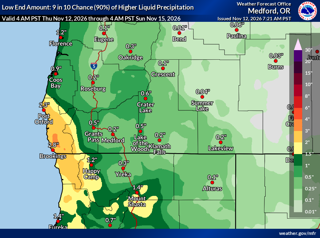
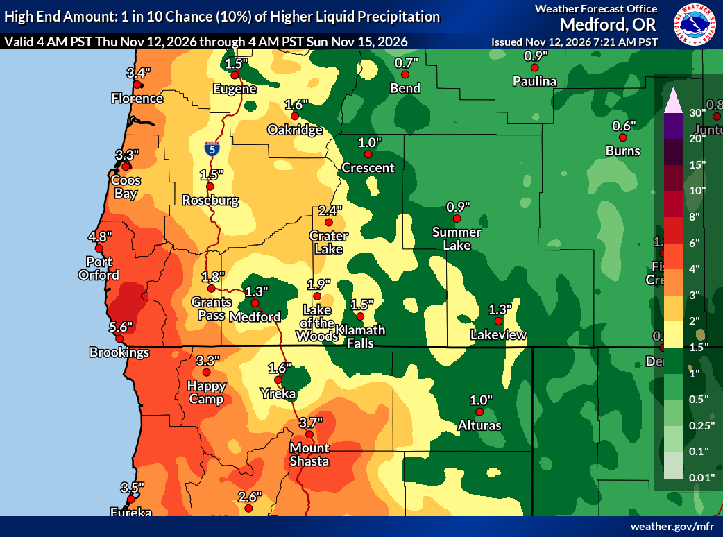
The less likely higher-end scenario, representing a 10% chance of being exceeded, shows rainfall potentially reaching 5.6 inches in Brookings, 4.8 inches in Port Orford, 3.7 inches near Mount Shasta and 1.8 inches in Grants Pass.
Actual rainfall totals are most likely to fall between these scenarios, although amounts outside that range remain possible. The projections reinforce the expectation that coastal areas and windward mountain slopes will receive considerably more precipitation than most inland valleys and east-side communities.
Rain will reach the coastal communities first, spreading across the Rogue, Illinois and Umpqua valleys during Friday. Areas east of the Cascades will generally experience their heaviest precipitation later Friday and Friday night.
Strong southerly winds will accompany the front, particularly along the coast, in the Shasta Valley and across the Klamath Basin and Lake County.
Temperatures will also drop sharply from Thursday's unusually warm readings. Medford, which is forecast to approach 70 degrees Thursday, is expected to reach only the mid-50s Friday. Klamath Falls will fall from the lower 60s Thursday into the upper 40s Friday.
DANGEROUS BEACH CONDITIONS: A powerful, long-period ocean swell is expected to produce exceptionally high surf along the Southern Oregon Coast Friday into Saturday, November 13–14. Breaking waves could reach 30 to 35 feet Saturday morning, potentially inundating beaches and causing erosion and dune overwash. Residents and visitors should remain well away from the shoreline, including jetties, rocks and driftwood. (National Weather Service Medford)
Dangerous Coastal Surf and Strong Winds
The Oregon Coast will face some of the most significant impacts from the incoming weather.
A High Wind Warning is in effect from 10 p.m. Thursday until 10 a.m. Friday along the southern Oregon Coast, where sustained south winds of 25 to 40 mph and gusts approaching 65 mph are possible, particularly near exposed headlands.
Strong winds could bring down trees and power lines, produce power outages and make travel difficult along Highway 101, especially for high-profile vehicles.
An additional threat will develop Friday as a powerful, long-period ocean swell reaches the coastline.
MARINE HAZARD RISK: The National Weather Service identifies elevated marine hazards along the Southern Oregon Coast from Saturday morning, November 14, through early Sunday, November 15. Hazardous seas and strong ocean swells will create dangerous conditions for vessels, particularly across the coastal waters offshore of Curry, Coos and Douglas counties. (National Weather Service Medford)
The National Weather Service has issued a High Surf Warning from 10 a.m. Friday until 10 p.m. Saturday for beaches along the southern and south-central Oregon Coast.
Breaking waves are expected to reach 20 to 25 feet Friday before increasing to 30 to 35 feet late Friday into Saturday, with the most dangerous conditions expected Saturday morning.
The exceptionally large surf could completely inundate beaches, carry water into normally dry areas, and cause substantial beach erosion and possible dune overwash.
Residents and visitors should remain away from beaches, jetties, rocks, driftwood and other exposed shoreline areas. Even locations that normally provide a safe viewing area could become hazardous during the event.
Dangerous beach conditions may continue into Sunday and Monday as additional swells move through the coastal waters.
Cover Photo / Powerful Pacific Surf: A massive ocean wave crashes against the rocky shoreline at Shore Acres State Park near Coos Bay, Oregon. The archival image illustrates the dangerous coastal conditions possible as a series of Pacific storms moves into the region beginning Friday, November 13, 2026. The National Weather Service forecasts breaking waves reaching 30 to 35 feet along portions of the Southern Oregon Coast Saturday morning. (File photo: Amy Williams/Oregon King Tides via Flickr)
Another Storm Follows Saturday Night
Although precipitation and winds should ease somewhat Saturday, the break will be relatively short.
Another Pacific frontal system is expected to arrive Saturday night, bringing renewed rainfall and gusty winds Sunday.
The second storm currently appears somewhat weaker than Friday's system, but it will add to the precipitation already received across the region.
Rainfall will again be most persistent along the coast and west of the Cascades, particularly across Curry County, where moderate to heavy rainfall is possible Sunday morning.
Farther inland, periods of rain will continue through Sunday, with cooler temperatures and additional snow at higher mountain elevations.
Snow levels, initially around 6,000 to 7,000 feet during Friday's storm, are expected to gradually decrease into the 5,000- to 6,000-foot range as colder air follows the weekend systems.
This will increase the potential for snow accumulation across higher portions of the Cascades, including the Crater Lake area.
Extended Forecast by Region: November 13–18
Oregon Coast — Brookings, Gold Beach, Port Orford, Bandon and Coos Bay
The coast will experience the wettest and most hazardous conditions during the opening weekend of the new weather pattern.
Rain becomes widespread Friday, accompanied by strong southerly winds. Highs will generally remain in the lower to upper 50s.
Rainfall continues Saturday, with another round of showers, locally heavy rain and possible thunderstorms Saturday night and Sunday.
The Brookings forecast indicates daily precipitation chances near 100% Friday through Sunday, with additional rainfall expected Monday.
Forecast amounts suggest that some coastal communities could receive several inches of rain over the weekend, particularly where successive systems focus precipitation along the coastal terrain.
Conditions may improve somewhat Monday night into Tuesday before another system brings additional rain Wednesday.
Dangerous surf will remain a major concern through the weekend, regardless of whether rain is falling at any particular location.
Inland Valleys — Medford, Ashland, Grants Pass and Roseburg
Western valleys will transition from warm and relatively dry conditions Thursday to a cooler, wetter pattern Friday.
Medford is expected to reach the mid-50s Friday, with widespread rain developing during the afternoon. Grants Pass will experience similar conditions, with rainfall likely beginning earlier in the day.
Rain continues Friday night, followed by a partial break Saturday when highs should recover into the mid-50s.
Another round of precipitation arrives Saturday night and Sunday, with rain likely throughout much of the region.
Sunday temperatures will generally range from the upper 40s to lower 50s, followed by cooler conditions Monday.
Rain chances may temporarily decrease Tuesday before another system approaches Wednesday.
The repeated rainfall will increase the potential for standing water on roadways, particularly in areas with poor drainage or accumulated leaves blocking storm drains.
Although widespread river flooding is not currently anticipated, motorists should be prepared for wet roads, reduced visibility and occasional localized ponding.
Northern California — Yreka, Weed, Mount Shasta, Dunsmuir and Alturas
Northern California will also experience a substantial change beginning Friday.
Rain is expected across Siskiyou County, including Yreka and the Mount Shasta region, where precipitation chances approach 100% Friday.
The Mount Shasta area could receive 1 to 2 inches of precipitation during the initial storm, with locally higher amounts in surrounding mountainous terrain.
Strong winds will accompany the frontal passage, particularly through the Shasta Valley, where a High Wind Warning is in effect Thursday night into Friday.
Yreka will see temperatures fall from the upper 60s Thursday to the upper 40s Friday, followed by highs generally in the upper 40s to lower 50s through the weekend.
Snow levels will lower Friday afternoon and evening, bringing the possibility of snowfall at higher elevations surrounding Mount Shasta and along mountain travel routes.
In Modoc County, Alturas will experience rain and gusty winds Friday, with highs near 50 degrees before temperatures fall into the upper 20s overnight. Rain may briefly mix with snow Friday night.
Another round of precipitation is expected Sunday into Monday, with additional rain and mountain snow possible as snow levels decrease.
Conditions may temporarily improve Tuesday before another disturbance approaches Wednesday.
MIDWEEK WINTER STORM POTENTIAL: The National Weather Service identifies a low-level winter storm risk across portions of the Southern Oregon Cascades, Klamath Basin, Lake County and Northern California from Wednesday morning, November 18, through early Thursday, November 19. Additional snowfall and changing travel conditions are possible as another Pacific weather system approaches. Forecast confidence and potential impacts will become clearer as the system draws closer. (National Weather Service Medford)
Mountains and Cascades — Crater Lake, Mount Ashland, Siskiyou Summit and the Southern Oregon Cascades
Mountain areas will experience some of the most significant temperature changes as the storm sequence develops.
At elevations near Crater Lake, rain and snow are expected Friday before precipitation changes to snow as temperatures fall.
The National Weather Service forecast near Crater Lake indicates approximately 1 to 3 inches of new snow Friday, followed by another 1 to 3 inches Friday night.
Additional snow showers are possible Saturday, with another more organized period of snow Sunday. Another 1 to 3 inches could accumulate Sunday before snow gradually decreases Monday.
These projections are location-specific, and snowfall totals could vary substantially across different mountain elevations and exposures.
Winds will also be a concern. Gusts near 50 mph are possible Friday around the higher elevations near Crater Lake, accompanied by temperatures falling into the lower 30s.
Mountain passes may initially receive rain, but falling snow levels could produce localized winter driving conditions, particularly at higher elevations and during overnight hours.
Travelers using Highway 62 near Crater Lake, Highway 140, Highway 97 and Interstate 5 near Siskiyou Summit should monitor changing forecasts and road conditions.
By Wednesday, another system may bring additional mountain snow, with preliminary National Weather Service outlooks indicating a low-level winter storm risk across portions of the Cascades and east-side mountains.
East Side Basins — Klamath Falls, Chiloquin, Lakeview, Bly and surrounding communities
East of the Cascades, the most immediate concern will be strong winds ahead of and during Friday's frontal passage.
Wind Advisories are in effect across portions of Klamath, Lake and Modoc counties Thursday night into Friday.
Klamath Falls will see temperatures drop from the lower 60s Thursday to the upper 40s Friday, with widespread rain and gusty southwest winds.
Friday wind gusts could approach 40 mph in Klamath Falls, while exposed areas elsewhere across the east side may experience stronger winds.
Rainfall amounts will generally be lighter than west of the Cascades, with approximately one-quarter to one-half inch expected from the initial system.
Lakeview will also see rain Friday, potentially mixing with snow as temperatures fall and snow levels decrease Friday night.
Saturday should bring a relative break, with mostly cloudy skies and highs in the mid-40s.
Another system arrives Sunday, bringing additional rain and renewed opportunities for a rain-snow mixture.
By Monday, snow levels could fall toward 5,000 feet or lower in some areas, increasing the possibility of snow reaching higher communities and surrounding roads.
Overnight temperatures will drop into the 20s and lower 30s early next week, creating the potential for icy conditions where wet pavement freezes.
Another precipitation opportunity is forecast Wednesday, with snow becoming increasingly possible across higher elevations of Klamath and Lake counties.
Unsettled Pattern Could Continue Into Next Week
The return of stormy weather is not expected to end with Sunday's system.
Additional showers are forecast Monday, followed by a possible short break Tuesday. Another Pacific front may arrive Wednesday, November 18, continuing the unsettled pattern.
Forecast confidence decreases farther into next week, particularly regarding the timing and intensity of individual storms. However, the overall pattern favors repeated precipitation opportunities rather than an extended return to the warm and dry conditions experienced earlier this month.
For western Oregon, the developing pattern could provide beneficial seasonal rainfall. For the Cascades and higher elevations of Northern California, falling temperatures and repeated moisture could begin contributing to early-season snow accumulation.
The National Weather Service currently considers widespread flooding unlikely from the first two systems, although localized ponding and small-stream responses remain possible where heavier rainfall develops.
Residents should pay particular attention to updated wind warnings, coastal hazards and changing mountain travel conditions as the storm sequence progresses.
Forecasts, warnings and advisories are available through the National Weather Service in Medford at weather.gov/Medford.


Keep Reading




A major shift in the weather pattern begins Friday as successive Pacific storms move into Southern Oregon and Northern California. Heavy coastal rainfall, dangerous surf, gusty winds and increasing mountain snow chances are expected, with unsettled conditions continuing into next week.