
Fielder Mountain Fire 90% Lined, 7% Contained
Evacuations ease as crews hold the fire at 548 acres
Fire Facts
Fire Name:
Fielder Mountain Fire
Location:
Rogue River, Ore.
Size: 548 acres
Containment: 7%
Activity:
Approximately 90% of the fire perimeter is lined.
Start Date:
Thursday, Aug. 13, 2026, shortly after 3 p.m.
Cause:
Vehicle-related; specific circumstances remain under investigation.
Personnel:
545 firefighters and support personnel
Resources:
17 hand crews
20 engines
8 heavy equipment
9 water tenders
8 aircraft
Evacuations:
1 Level 2 (Be Set)
1 Level 1 (Be Ready)
No Level 3 (GO NOW) zones remain.
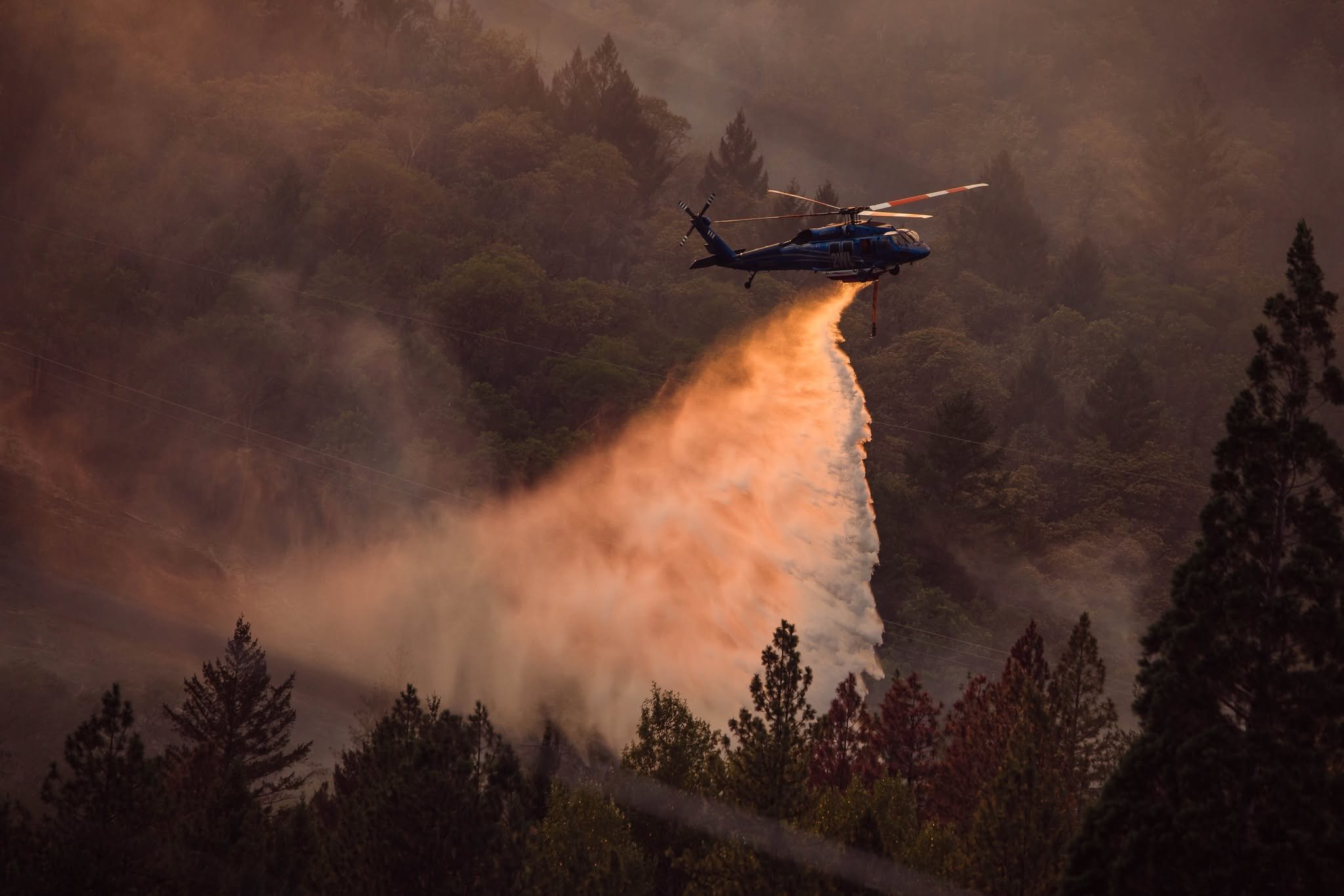
Helicopter Water Drop / Cover Photo: A helicopter drops water on the Fielder Mountain Fire during aerial suppression operations on Aug. 13. Shelby Snow Photography.
Updated 1:20 PM
ROGUE RIVER, Ore. — Firefighters held established control lines around the Fielder Mountain Fire overnight and continued closing gaps around the perimeter, bringing the fire to approximately 90% lined Saturday morning.
An overnight infrared flight mapped the fire at 548 acres, while containment remains at 7%, according to Oregon Department of Forestry Complex Incident Management Team 1.
The progress comes less than two days after the fire raced uphill from Interstate 5 west of Rogue River, prompting evacuations and a large air and ground response. Evacuation levels have since been significantly reduced, with no Level 3 zones remaining Saturday morning.
For firefighters on the mountain, however, the work is far from finished.


Crews completed additional line along the southwestern portion of the fire overnight, creating continuous hand line along the western edge. Bulldozers reinforced existing hand line on the north side, while firefighters strengthened four areas along the eastern perimeter where fire had attempted to cross established control lines.
Along the southern portion of the fire near homes, crews continued the slower work of mop-up, checking for heat that could flare again as temperatures rise. ODF reports firefighters have mopped up between 50 and 100 feet around structures in some areas.
Operations Section Chief Kyle Gibbons said crews are also using thermal imaging cameras along portions of the perimeter to locate heat that may not be visible from the surface.
Although approximately 90% of the fire now has control line around it, that is not the same as containment. Containment remains at 7% while firefighters strengthen those lines and gain confidence that the fire will remain within them.
Crews Work to Close Remaining Gaps
ODF CIMT 1 assumed command of the Fielder Mountain Fire at 6 p.m. Friday after receiving the incident from Southwest Oregon District firefighters and partner agencies that handled the initial attack.
The incident now has 545 personnel assigned, including 17 hand crews, 20 engines, eight pieces of heavy equipment, nine water tenders, and eight aircraft.
Crews on the Line: Firefighters move across steep terrain near a dozer while working the Fielder Mountain Fire on Aug. 13. Shelby Snow Photography.
Crews are concentrating Saturday on the remaining portions of uncompleted line while continuing to improve hose lays around the perimeter.
Some of the most difficult work remains near the upper portions of Division G, where steep terrain and rough access have made it difficult to get water to firefighters. Aircraft are expected to support crews there while additional hose is moved uphill.
Firefighters are also continuing to watch for flare-ups, slopovers, and burning material rolling across control lines.
Briefing Map: ODF Complex Incident Management Team 1’s Aug. 15 briefing map shows the 548-acre Fielder Mountain Fire perimeter, completed hand and dozer lines, planned line, access routes, and operational divisions around the incident west of Rogue River. Oregon Department of Forestry.
In steep terrain, a burning tree or piece of debris can fall or roll downhill, cross an established line, and force crews to return to an area they had already worked. Firefighters then have to connect the new spot back into the existing perimeter with hand or dozer line.
Conditions improve farther east toward Division L, where crews were able to pump water farther up the line overnight.
Near homes in Division W, firefighters continued mop-up and used thermal imaging equipment to search for remaining heat. In Division C, crews are improving existing hand line and constructing trenches in places where rolling material could threaten the perimeter.
A contingency group is also looking for locations north of the fire where an alternate control line could be established between the fire and nearby homes. The additional line would serve as a precaution should fire activity increase.
Temperatures are expected to reach the low 90s Saturday, with light winds and another chance of thunderstorms.
Fire managers say warmer conditions and wind could test portions of the perimeter, while lightning creates the additional possibility of new wildfire starts elsewhere across Southwest Oregon. Resources assigned to the Fielder Mountain Fire are prepared to assist local firefighters with initial attack if new fires are reported.
Evacuations Significantly Reduced
Evacuation levels around the Fielder Mountain Fire have been reduced as firefighters make progress securing the perimeter.
Current Jackson County evacuation zones are:
Level 2 (Be Set): JAC-052
Level 1 (Be Ready): ROR-053
No Level 3 (GO NOW) evacuation zones remain, and evacuation notices previously issued in Josephine County have been removed.
Residents near the fire should continue monitoring official evacuation information because conditions and zone boundaries can change.
A shelter for people and pets remains open at North Middle School, 1725 NW Highland Ave. in Grants Pass. Livestock sheltering remains available at the Jackson County Expo, 21 Peninger Road in Central Point.
Interstate View: Light smoke rises from the Fielder Mountain Fire west of Rogue River as seen from Interstate 5 Saturday. Oregon Department of Forestry.
Foothill Boulevard remains closed from the Rogue River city limits to the Josephine County line. Drivers are being asked to use an alternate route.
Firefighters and aircraft will also continue operating near Interstate 5, and motorists should slow down, remain alert for emergency vehicles, and give crews room to work.
Smoke from the Fielder Mountain Fire may settle into valleys and other low-lying areas, reducing visibility and affecting air quality in nearby communities.
A 24-hour Temporary Flight Restriction remains in place over the fire area. Drones are prohibited around the incident because they can interfere with firefighting aircraft and create a safety hazard for pilots and crews.

Fire Started Along Interstate 5
The Fielder Mountain Fire began shortly after 3 p.m. Thursday, Aug. 13, along northbound Interstate 5 near Mile Marker 51 west of Rogue River.
ODF has classified the fire as vehicle-related. The specific circumstances surrounding how the vehicle sparked the fire remain under investigation.
Initial reports indicated tires on a semi-truck were burning before flames spread into nearby vegetation.
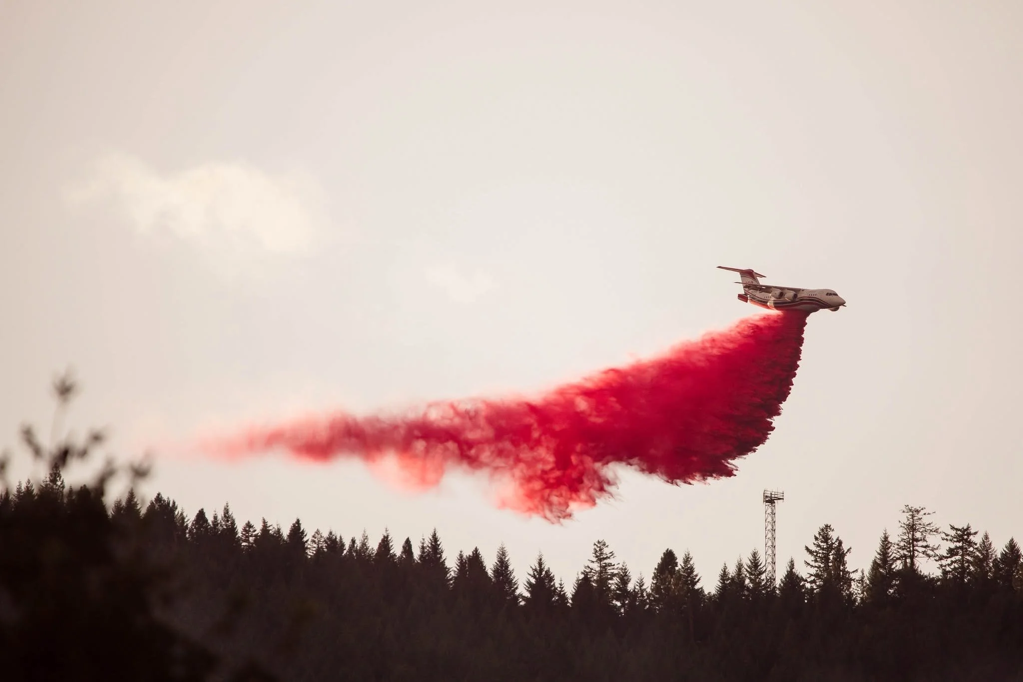
Air Tanker Drop: An air tanker lays retardant along the Fielder Mountain Fire as smoke hangs over the hillside on Aug. 13. Shelby Snow Photography.
The fire grew rapidly Thursday afternoon in hot, windy conditions, pushing uphill through steep terrain and producing spot fires as aircraft and ground crews worked to slow its spread.
By Friday morning, firefighters had completed line around approximately 70% of the perimeter. That increased to roughly 75% by Friday afternoon and approximately 90% by Saturday morning.
ODF Complex Incident Management Team 1 will continue directing suppression operations Saturday as crews work to close the remaining gaps, strengthen existing control lines, and keep the fire from gaining additional ground.


Keep Reading




