
Structure Protection Shifts South as Wrights Spring Fire Crews Secure Northern Areas
Crews continue preparing structures and building fireline near Egert Road, Swan Lake, and the southern flank.
Heat Detections: Recent satellite heat detections show the strongest current activity concentrated along the south and southwest portions of the Wrights Spring Fire, while much of the larger burn footprint shows little or no recent heat. NIFC Emergency Geospatial Portal.
FAST FIRE FACTS
Name:
Wrights Spring Fire
Location:
Approximately 17 miles NNE of Klamath Falls
Size: 53,032 acres
Containment: 6%
Personnel: 948
Evacuations:
32 Level 3 (GO NOW) zones
27 Level 2 (Be Set) zones
34 Level 1 (Be Ready) zones
Command:
Northwest Team 8 and OSFM Green Team, Unified Command
Activity:
Crews are securing and patrolling northern portions of the fire while line construction and structure protection efforts remain focused on the south and southwest.
KLAMATH FALLS, Ore. - The Wrights Spring Fire is now 53,032 acres and 6% contained Thursday morning as firefighters continue reporting progress around much of the incident while concentrating line construction along the south and southwest portions of the fire.
The incident has grown by about 500 acres since Wednesday morning, while staffing has increased to 948 personnel. Crews continue patrolling and strengthening established lines on the north and east sides as work progresses around Egert Road, Rattlesnake Springs, Swan Lake, and Swan Lake Point.
Firefighters encountered increased activity near Swan Lake Point overnight, including several spot fires. Fire officials said crews were able to catch and contain each of those spots while continuing to secure the western edge.
Oregon State Fire Marshal officials also say the threat to structures is beginning to decrease in several areas. For the first time since the fire began, officials have confirmed structural losses, including one primary structure and three outbuildings destroyed early in the incident.
The most active suppression work Thursday continues around the southern and southwest portions of the Wrights Spring Fire.
Highway 140: Smoke from the Wrights Spring Fire is visible from Highway 140 near Bliss Road on Aug. 12. Photo by Jodie Schiffman / Northwest Team 8.
Night crews constructed check line and completed a small firing operation near Egert Road to help secure the southern edge and create time for firefighters to continue building line farther south.
Crews will continue constructing line from Egert Road toward Rattlesnake Springs, then west toward Swan Lake before turning northwest toward Swan Lake Point.
Firefighters are also preparing portions of the southwest side for possible nighttime firing operations.
On the western side, crews will continue holding and patrolling established line north from Swan Lake Point toward Saddle Mountain. A contingency group is also preparing additional line near Yainax Road in case primary containment efforts are unsuccessful.


NORTH END MOVES FURTHER INTO PATROL
Conditions continue to improve across much of the northern portion of the incident.
Crews around Saddle Mountain spent the night patrolling and securing established fireline, while firefighters from Skeen Ranch Road to Horton Reservoir continued holding previous firing operations and improving lines constructed during earlier shifts.
Structure protection officials said the LD Road, Saddle Mountain, and Skeen Ranch Road areas are increasingly moving toward patrol status.
Residents may begin seeing fewer structure protection engines in those areas as resources are shifted elsewhere, although crews will continue monitoring the fire and remaining available if conditions change.
Hot Spots / Cover Photo: Multnomah County Task Force firefighters extinguish remaining hot spots on the Wrights Spring Fire on Aug. 10. Oregon State Fire Marshal Green Team.
OSFM structure protection crews continue working around Bly Mountain and other areas that remain potentially exposed to the fire, but officials say the overall structural threat is beginning to decrease.
Crews around Bly Mountain will continue precautionary structure assessments and preparation along portions of the western road system. Firefighters are also preparing around historic structures near the southern end of the incident.
OSFM and the Klamath County Sheriff’s Office confirmed Thursday that one primary structure and three outbuildings were destroyed earlier in the fire.
Officials said additional damage could still be identified as conditions improve and previously inaccessible areas become safe enough to assess.
MORE MOISTURE MOVES INTO THE AREA
Weather conditions are becoming somewhat more favorable for firefighters.
Increasing moisture is expected over the next 36 hours, with relative humidity remaining above 25%. Thursday and Friday are forecast to remain warm and breezy, but temperatures will be cooler than earlier in the week.
Ridgetop temperatures are expected in the mid 70s, with valley temperatures in the low 80s and relative humidity between 26% and 30%.
Smoke impacts across much of the Klamath Basin are expected to be less severe Thursday than earlier in the week.
The latest wildfire smoke outlook calls for generally good air quality in Klamath Falls and Chiloquin with periods of moderate smoke possible. Bonanza may experience moderate conditions during the morning before improving later in the day.
Visible haze and localized smoke will remain possible as winds shift smoke around the region, particularly during the evening and overnight hours.
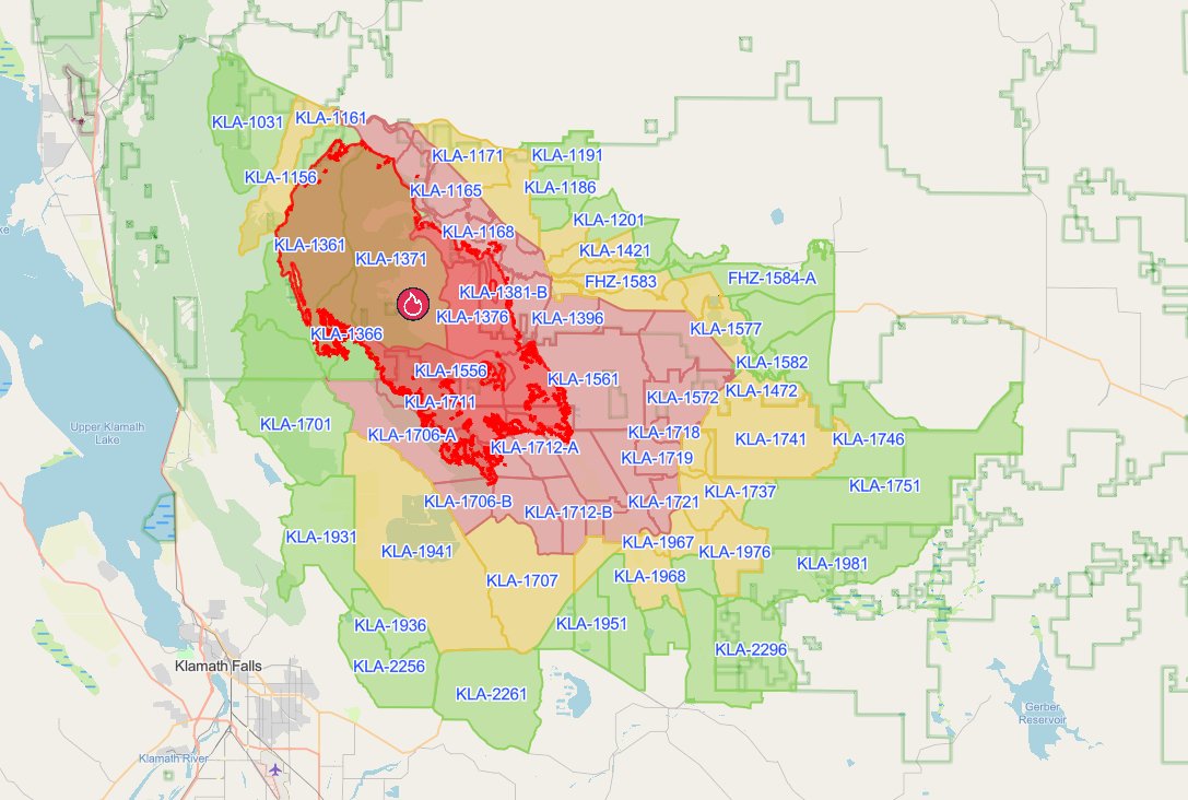
Evacuation Areas: Genasys Protect shows the latest Level 1 (Be Ready), Level 2 (Be Set), and Level 3 (GO NOW) evacuation zones surrounding the Wrights Spring Fire as of 10:30 a.m. Thursday. Genasys Protect.
EVACUATIONS REMAIN IN EFFECT
Multiple evacuation levels remain in effect across southern Klamath County, with 32 zones at Level 3 (GO NOW), 27 zones at Level 2 (Be Set), and 34 zones at Level 1 (Be Ready) Thursday morning.
Although fire officials report a declining structural threat in some northern areas, evacuation zones remain in place across a broad area surrounding the Wrights Spring Fire. Residents should continue checking their specific address through Genasys Protect because evacuation levels can change as suppression work progresses.
View the latest Wrights Spring Fire evacuation information and live map.

SHELTERS AND CLOSURES
Red Cross emergency shelters remain open at Chiloquin Elementary School, 548 S. 2nd Ave. in Chiloquin, and Living Springs Fellowship, 31897 Mission St. in Bonanza. Small animals may accompany evacuees.
Large animal sheltering remains available at the Klamath County Fairgrounds through Southern Oregon Emergency Aid.
Sprague River Road remains closed from milepost 9 to Sprague River Drive. Bliss Road remains closed from Petersteiner Road to Sprague River.
The Fremont-Winema National Forest emergency closure surrounding much of the Wrights Spring Fire also remains in effect.
A Temporary Flight Restriction remains over the incident. Drones are prohibited near the fire because unauthorized aircraft can interfere with and potentially ground aerial firefighting operations.


Keep Reading




