
Wrights Spring Fire Grows to 51,687 Acres as Crews Strengthen Southern Lines
Firefighters report progress on the north end while structure protection expands near Bly Mountain and Swan Lake.
Fast Fire Facts
Name:
Wrights Spring Fire
Location:
Approximately 17 miles NNE of Klamath Falls
Size: 51,687 acres
Containment: 0%
Personnel: 656
Evacuations:
35 Level 3 zones
27 Level 2 zones
33 Level 1 zones
Command:
Northwest Team 8 and OSFM Green Team, Unified Command
Activity:
Crews are strengthening control lines as the fire remains active to the south and southeast, while previously completed lines continue to hold on the north end.
Smoke Column / Cover Photo: A large smoke column from the Wrights Spring Fire rises over Hogback Mountain, Klamath Falls, and the Klamath County Fairgrounds as an American flag flies at half staff Tuesday. Northwest Team 8.
CHILOQUIN, Ore. — The Wrights Spring Fire has grown to 51,687 acres Tuesday morning as firefighters report progress securing portions of the northern perimeter while continuing an aggressive effort to contain the fire’s south and southeast spread.
Crews completed additional firing operations overnight, strengthened dozer lines near Bliss Road, and connected portions of line along the southeast side of the fire. The earlier strategic burn near Saddle Mountain also continues to hold, with firefighters reporting no spot fires across those lines.
The incident remains 0% contained with 656 personnel assigned. Structure protection is continuing around Bly Mountain, Yonna Woods, Bliss Road, and the Swan Lake area as warm, very dry, and breezy conditions persist across southern Klamath County.
CREWS MAKE PROGRESS ON MULTIPLE FRONTS
Firefighters reported several successes from overnight operations.
In Division C, crews completed firing operations along Forest Road 1119 and connected additional dozer line on the southeast corner of the fire. Crews working west from Bliss Road also constructed more line and began burning remaining fuels between the fire and previously built control lines.
That work will continue Tuesday as firefighters strengthen the southern perimeter and work toward connecting line west from Bliss Road to Swan Lake Point.
On the north end, crews in Divisions R and X continue holding and securing the strategic burn completed earlier around Saddle Mountain. Fire officials said the burn continues to hold with no spot fires found outside the line.
Crews on the northwest side will continue strengthening existing lines and connecting them with other completed portions of the perimeter.


STRUCTURE PROTECTION EXPANDS SOUTH AND EAST
Oregon State Fire Marshal crews are again operating in three structure protection groups Tuesday.
The north group continues working around the Sprague River area, where fire officials say conditions have improved enough in some locations that resources may begin shifting elsewhere.
Farther southeast, crews continue preparing and assessing properties around Bly Mountain, Yonna Woods, and nearby road systems. Firefighters are improving defensible space where possible and identifying structures that could require point protection if the fire pushes farther southeast.
A third group is working around Bliss Road, Egert Road, and the Swan Lake area.
Fire officials said structures along Egert Road could potentially fall within the fire footprint Tuesday if the southern edge continues advancing. Crews are also assessing homes and agricultural properties around Swan Lake in preparation for possible additional movement.
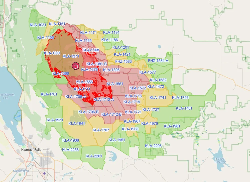
Evacuation Areas: The latest Genasys Protect map shows Level 1 (Be Ready), Level 2 (Be Set), and Level 3 (GO NOW) evacuation zones surrounding the Wrights Spring Fire across southern Klamath County. Genasys Protect.
EVACUATIONS REMAIN WIDESPREAD
Evacuation areas continue across a large portion of southern Klamath County.
As of 11:50 a.m. Tuesday, 35 zones are Level 3 (GO NOW), 27 are Level 2 (Be Set), and 33 are Level 1 (Be Ready).
Level 3 areas continue across much of the central and southeast evacuation footprint, while Level 2 and Level 1 zones extend outward toward Highway 140 and communities farther south and east.
Evacuation boundaries have changed repeatedly throughout the incident. Residents should continue checking their specific address rather than relying on earlier maps or social media posts.
View current Wrights Spring Fire evacuations and the live Genasys Protect map.
Fire Activity: A large smoke column rises from the Wrights Spring Fire on Aug. 10 as active fire continues across southern Klamath County. Northwest Team 8.
HOT, DRY WEATHER CONTINUES
Warm, very dry, and breezy weather is expected Tuesday and Wednesday.
Ridgetop temperatures are forecast in the mid 80s, with valley temperatures reaching the low 90s. Relative humidity is expected to fall between 13% and 16%.
Those conditions will continue to challenge firefighters working along the southern and southeast portions of the fire.

SHELTERS, SUPPORT AND CLOSURES
Red Cross shelters remain open at Chiloquin Elementary School, 548 S. 2nd Ave. in Chiloquin, and Living Springs Fellowship, 31897 Mission St. in Bonanza. People may bring small animals to either location.
The Klamath County Fairgrounds / Event Center is serving a different role. The facility is being used as the Wrights Spring Fire Incident Command Post and as a designated shelter for evacuated livestock and other large animals. Large animal sheltering is being coordinated through Southern Oregon Emergency Aid.
How to Help: Fire officials are asking people who want to help to direct donations toward evacuees, local organizations, and volunteer fire departments rather than bringing supplies directly to fire camp. Northwest Team 8 / Oregon State Fire Marshal. (Tap to enlarge)
Fairgrounds officials emphasized in a public statement that the Event Center is “not a public evacuation shelter for people.” The facility needs to remain available for firefighters, emergency personnel, support crews, and incident operations.
The Event Center has also received numerous offers of donations and assistance. Officials are asking residents to check with local fire departments, emergency management agencies, and other organizations for current needs rather than bringing supplies directly to the fairgrounds or fire camp.
WANT TO HELP?
Fire officials continue to emphasize that firefighters assigned to the Wrights Spring Fire are already supplied for their assignments, and incident management teams cannot accept most donated food, water, or other supplies at fire camp.
Instead, people looking to help are being encouraged to support evacuees, local organizations, volunteer fire departments, the American Red Cross, the Wildland Firefighter Foundation, and other groups assisting communities affected by the fire.
Jefferson Firewatch outlined current donation locations and recommended ways to help in Monday’s update: See where Wrights Spring Fire donations are needed most.
Forest Closure: A large Fremont-Winema National Forest closure remains in effect around the Wrights Spring Fire. Fremont-Winema National Forest.
ROAD AND FOREST CLOSURES
Fire officials are asking the public to avoid unnecessary travel near the incident because of heavy fire traffic and ongoing suppression activity. Engines, heavy equipment, and crews are moving throughout the area, and keeping roads clear is important for both firefighter safety and evacuation access.
Sprague River Road remains closed from milepost 9 to Sprague River Drive. Bliss Road remains closed from Petersteiner Road to Sprague River.
The Fremont-Winema National Forest emergency closure surrounding much of the Wrights Spring Fire also remains in effect.
The emergency closure covers National Forest System lands, roads, and trails across a broad area surrounding the fire and is scheduled to remain in effect through Oct. 31 unless rescinded sooner. Highway 97, Highway 140, and Sprague River Road are not included in the Forest Service closure, although portions of those routes form the closure boundary.


Keep Reading




